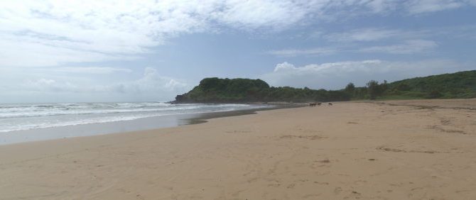
When imagining holidays, it is common to put yourself on a shack on a quiet beach. At nearly 700 km, Maharashtra state has one of the longest coastlines in the entire country. The coastline is dotted with several beaches, both popular and secluded. But that’s not all. Maharashtra is probably one of the few states in India which has several forts, many belonging to Marathas, but some built by other rulers such as Bahamanis, Siddhis and Portuguese. Coastal Maharashtra (or Konkan as it’s called locally) is not plain. It is a series of flat beach strips interspersed by hill ranges. There are many vistas where you will see the sea waves crashing into the base of hills. To complete your enjoyment, Konkani food is extremely delicious. In this post, we will tell you about how we covered Konkan region, its beaches and its many sights worth visiting. Continue reading →
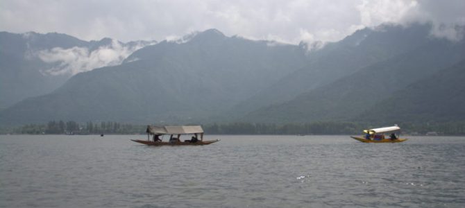
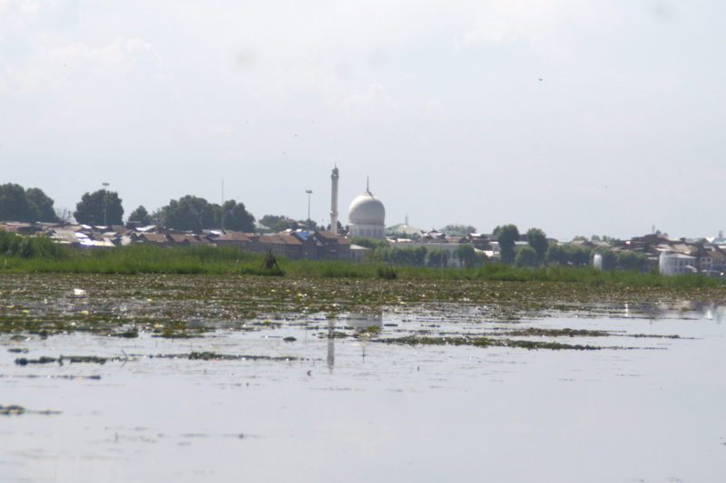
Movies from around India have shot romantic duets on the snowy slopes and among the pine trees of Kashmir. But it is only when you take in the beauty of Kashmir with your own eyes that you realise how really beautiful it is. In the middle of the valley is a system of lakes and the Jhelum river, around which the capital city Srinagar has evolved. The city has really old roots, going well back to the days when Takshila University was a hub for students around the world to flock to. There is so much to see and do at Srinagar, but at the same time, it is just enough to sit down, relax and simply soak in the ambience of the Dal Lake and the snow-capped peaks surrounding it. Here is what we learned about Srinagar during our visit, along with a list of what you can do there.
Geography of Srinagar
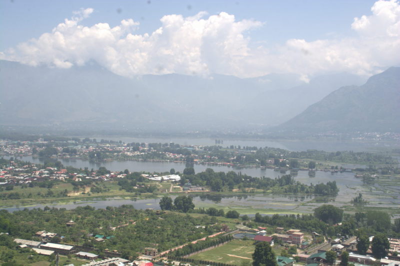
Kashmir is a maze of high-peaked snow mountains interspersed with large flat valleys that have a number of major rivers and lakes. Among one such flat expanse of land that contains the Dal Lake and the Jhelum river, the city of Srinagar has grown to what it is today. Dal is one of the many lakes in Srinagar. There are others like Nigeen and Wular, all connected to each other by canals. Based on the lakes and their banks, we can classify Srinagar into two parts: the city on land and the city that thrives in water. That’s true. Along with the part of Srinagar’s landmass that stretches from Ganderbal suburb in the north to Badgam in the south, there is a complete settlement that lives inside the lake itself, with unique areas like Meena market and Char Chinar island.
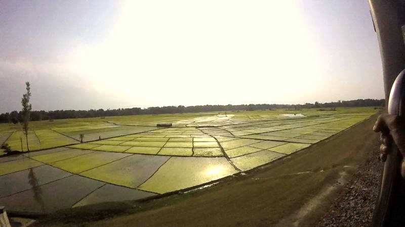
Scenes like these are plentiful in Kashmir. Flat tracts of land with acres of cultivated farms. It is a fallacy that the whole of Kashmir is mountainous, bitterly cold and covered in snow. Rivers like Jhelum ensure that the valley lying at lower altitudes are fertile and green.
To the south and south-east of Srinagar is the flat expanse of Kashmir valley, highlighted by large farmlands which grow saffron, apples, fruits and vegetables. To the west of Srinagar are the mountains that lead to Gulmarg hill station and its skiing institute. To the north, you will come across Himalayan mountains that are sparsely inhabited and lead to the Line of Control with Pakistan. Driving to the east of Srinagar, you can reach other interesting destinations such as Sonmarg, Kargil and Ladakh. The Jhelum river, that originates at Wular lake and flows near the Lal Chowk junction, marks the end of Lake Area Development Authority of Srinagar and seperates the city from the southern suburbs.
In Kashmir valley, one can spot many varieties of pine trees, but the one that is most revered is the Chinar tree, with its clovered leaf looking like a Canadian maple. Chinar is sometimes referred to as the Indian maple.
People of Srinagar
While the name Srinagar has Hindu roots, majority of the city is Islamic. They are the Kashmiri Muslims who are locally called ‘Koshur’. Ramzan is an important month for Kashmiri Muslims just like Muslims around the world. Without getting controversial, let me just state that the other ethnic group, Kashmiri Hindu Pandits, are very few in numbers in Kashmir region itself and are rare to come across anymore. You can also find Sikhs in Sikh colonies around Kashmir.
Kashmiris speak Kashmiri language which is a descendent of Farsi tongue from Iran. During India 360, we found Kashmiri to be the sweetest and the best sounding language. Hands down. No other Indian language, the way it is spoken on the streets, comes close to the melody that day-to-day Kashmiri produces. It is easy to assume that Hindi is spoken throughout Kashmir. But in reality, what you hear is Urdu. It is common for people to use terms like ‘Janab’ when they address you. The two languages are identical to hear. But Hindi uses Devnagari script and plenty of Sanskrit words, whereas Urdu uses Arabic script and plenty of words derived from Arabic, Farsi and Afghan. The youth of Kashmir are very fluent in English too.
Kashmiris have plenty of occupations. Most people are connected to agriculture and the processing and trade of agricultural products. The highest selling agricultural product are Kashmiri saffron, Kashmiri apples and Rose Gulkand. Other fruits and nuts like apricots, figs, almonds and walnuts are also grown and traded here. Exquisite wood carving, elaborate carpet weaving and the production of woollen bedsheets and blankets, especially with Pashmina wool are major and flourishing occupations for the people here.
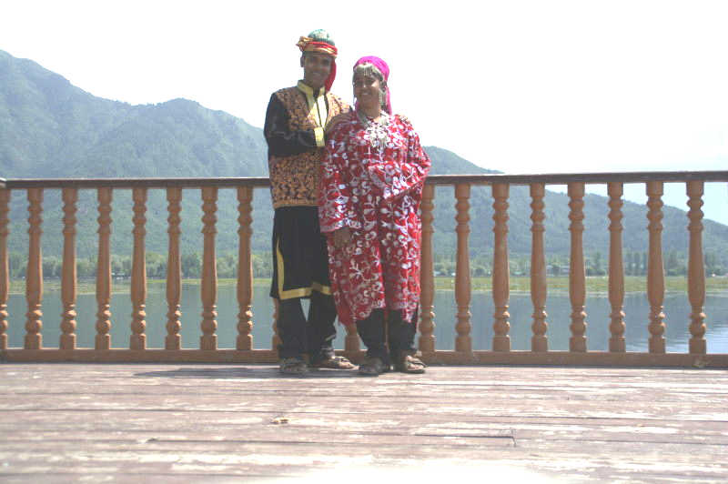
We are not Kashmiri, but we got to dress up like them 🙂
Let’s now look at the places to visit in Srinagar
Dal lake boat ride
if you are given just one day in Srinagar, then this is what you should do. Taking a boat ride in one of the local boats, named shikaras, is a unique experience and can only be done in Srinagar. The magnificently constructed boats have a curtained chamber and you can just sit back and relax while the boatman takes you on a ride around Dal and Nigeen lakes. On the way, you’ll be shown landmarks like Hazratbal, areas like Rainawari, the view of the snowcaps around Gulmarg and the lake market called Meena Bazaar. Dal lake boat ride should be the one thing you should not miss when in Srinagar. You can get shikaras on the eastern bank of the lake, at one of the gates that face the main road, which is called the Boulevard road.
Dal lake shikara ride
The only caveat about these rides is that there are too many vendors. Too many jewellery sellers, snacks sellers, flower sellers and spice sellers approach your shikara and sell hard to get you to buy their wares. Thankfully, these are restricted to the lake area closer to the city. Once you leave the city and are in the depths of the lake, you will only find mangrove shades and migratory birds. Snow-capped mountains in front of you and a tranquil peace around you. It’s hard to say whether you should keep your eyes open for the beauty around you or keep your eyes shut to enjoy the tranquility. That’s confusing. But the one certain is NOT to TALK during a tranquil shikara ride. The song from Mission Kashmir, ‘Chup ke se sunn, is pal di dhun’ (Hindi song that says: Stay silent and listen to the tunes of this moment) rings true.
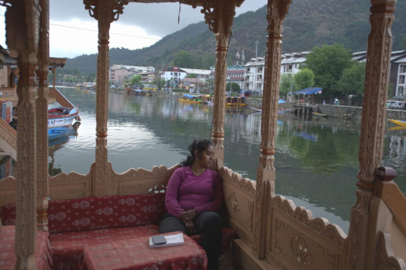
Dal lake boathouse stay
A boat ride will show you around the lake, but what about staying inside the lake itself. You should check out the boathouses that line the Dal Lake gates 1 – 10 (eastern bank of the lake). These are entry level boat houses, but still look fabulous, with their wood carved bed headboards and window frames. For breakfast, you will be served Kashmiri bread and Nun Chai, which is a salty version of tea, slightly pinkish in colour. Then comes the exotic tasting Kahwa, a non-milky tea infused with the taste of saffron and cardamom. It is customary for Kashmiris to treat special guests with a cup of kahwa and you will be treated no less than a very special guest.
Enjoying the idle and beautiful setting of a Kashmiri boathouse on Dal lake.
But the best thing to do on a boathouse is to take one of seats along the verandah and sit gazing at the lake and the city. It is quite relaxing.
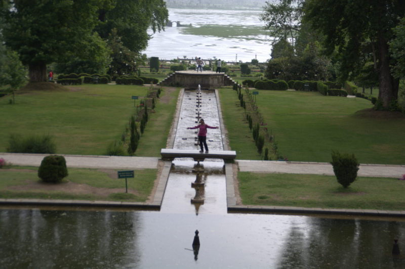
Mughal-style gardens
Being a city ruled for long by Muslim monarchs, you can expect their landscaped lawns, rose gardens and fountains to crop up around the city. Haider Ali and Tipu Sultan, while ruling over Srirangapatna for just 49 years between them, built a palace and a garden. Then what can you say about Srinagar? Well, there are 5 Mughal style gardens around Srinagar, all in different areas. But the theme in each of them is the same. Lawns, rose beds and multi-coloured flower beds in multiple terraces at increasing levels, with water fed by a central fountain. The five Mughal style gardens are: Mughal Bagh, Shalimar Bagh, Nishat Bagh, Chashme Shahi Bagh and Badamwari.
Nishat Bagh is very close to Dal lake.
Each of these gardens were built either by the incumbent rulers or by their ministers, mostly as a statement to exhibit their artistic taste. These were mostly a show of one-upmanship as the latest garden was built in more opulent a style than the last one. But who are we to care? The intense competition makes it great for us to visit Srinagar and feast our eyes upon beautiful fountains and magnificent flowers.
Hari Parbat
Hari Parbat is a hill on the western bank of Dal Lake, opposite to the side you usually embark on boat rides. The name of the hill is due to the fact that the fort at the top was used by the last monarch of Jammu Kashmir, Raja Hari Singh. The fort at the top of the hill was built by Mughal emperor Akbar. There is also a Gurudwara, a dargah and a temple. The hill can be reached by bus or Sumo taxi that is bound to Rainawari. You should alight at ‘Maqdoom Sahib ropeway’. A little distance ahead is a narrow road that winds up the hill. After a kilometre uphill, the road ends and a stairway starts. This stairway goes all the way to the top, with branching stairways to important points along the way. The hill is now patrolled by the Indian Army, who have a vantage view of the entire city from here.
The city of lakes is in full display from the top of the Akbar fort, along with the surrounding Himalayas.
Akbar fort has bastions with viewpoints towards Srinagar. There are also dungeons and a place for execution. Another important place is the Swayambhu (self-formed) temple of Lord Shakti called Sharika Devi, a deity with 18 arms.
Dargah Maqdoom Sahib is on the side of the hill away from the staircase and can be reached by taking a ropeway from the base.
Shankararchya Hill
While Hari Parbat is to the west of the lake, Shankaracharya Hill is to the east, the same side as the gate for shikaras and also the side where you can visit most of the Mughal-style gardens. Thus, it makes sense to combine this hill with a boat ride and garden visits, while Hari Parbat and Badamwari garden (the only Mughal garden to the west of the lake) should be combined with a visit to Rainawari old town.
Adi Shankaracharya performed his own version of ‘India 360’, but during the 8th century, with no motor transport, no trains, no personal vehicle or planes. This revered man went to several places teaching the principles of Hinduism and establishing some of the most important temples in India. One of them is the Jyeshteshwara temple at the top of the hill that faces Srinagar from the east. Today we know this hill to be the Shankaracharya hill.
Rainawari and Hazratbal
A view of Hazratbal from Dal Lake.
Hazratbal is a holy mosque in Rainawari township on the western bank of Dal lake. This area is the traditional Srinagar with old houses and narrow streets that have developed organically over centuries, rather than the highways and modern buildings on the east that has been developed recently by LADA (Lake Area Development Authority). LADA has left Rainawari alone to preserve it in its traditional state.
Hazratbal is considered holy among Muslims as the mosque that is home to Prophet Mohammad’s hair. While no one is allowed to see the Holy Hair on normal days, it is brought out for public viewing on special days such as the Prophet’s birthday as per the Muslim calendar.
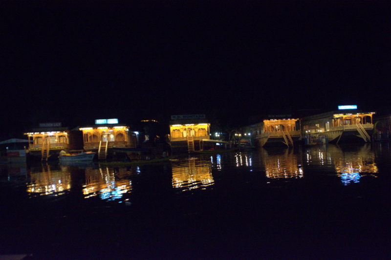
Boulevard road
Houseboats in Dal lake at night, as seen from Boulevard road.
If you are not in a mood for sight-seeing, you can simply take a walk on the portion of the Boulevard road that runs parallel to the Dal lake’s eastern side for several kilometres. Of significance is the portion between Dal Gate 1, where the road starts, upto Nishat Garden. It is quite a sight to see multi-coloured boats floating on the water.
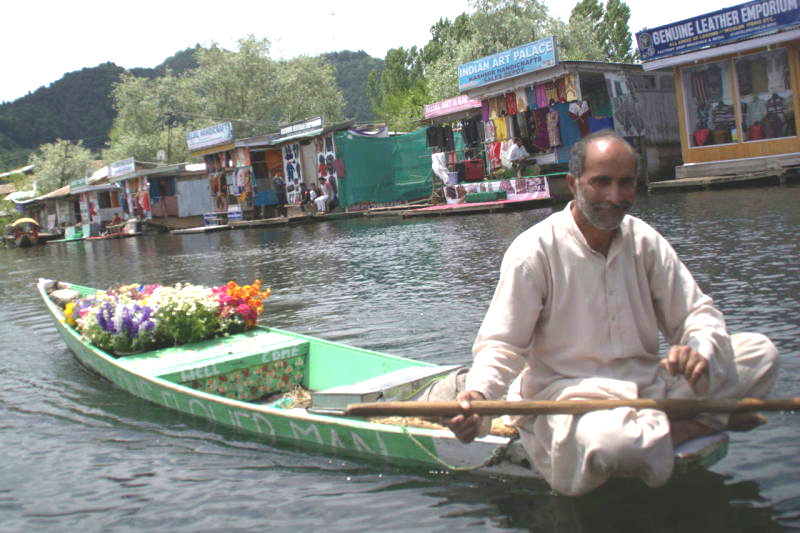
Meena Bazaar
A flower seller on his boat in Meena Bazaar.
When you take a boat ride in a shikara, the boatman will inevitably take you through Meena Bazaar, a floating market where vegetables, fruits, flowers and handicrafts are sold from boats that act as shops. We bought a Pashmina bedsheet from Meena Bazaar.
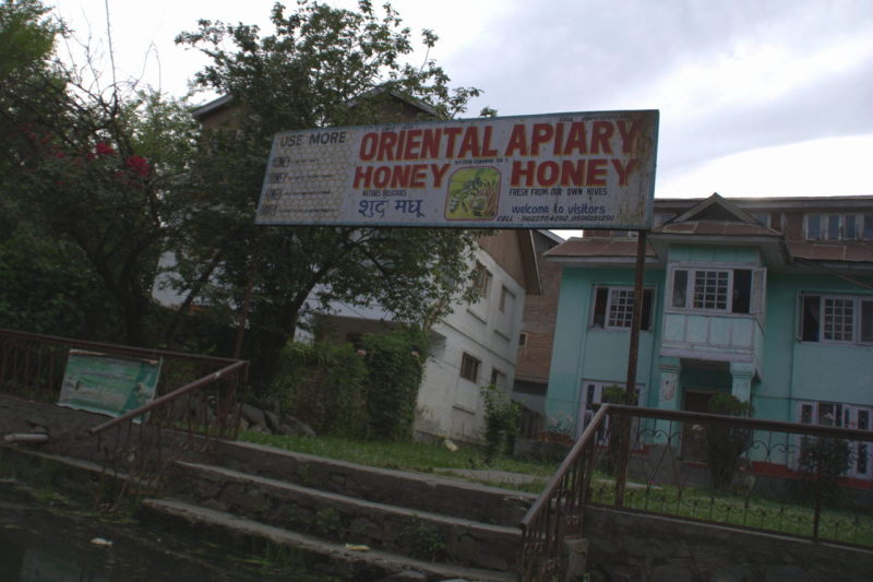
Rainawari lakeside shops
While Meena Bazaar is a floating market, the Rainawari Bazaar is a regular market on land, but with a difference. At Rainawari, the Dal lake narrows down into a canal that feeds into the Nigeen lake. On both sides of the canal, you can see shops that sell food, handicrafts and fresh produce. Of significance in this market, are apiaries that sell fresh honey produced from different types of flowers. Each honey has a health benefit for different parts of the body. Along with honey, the apiaries also sell beeswax.
Oriental apiary is a business where different varieties of honey are extracted by breeding cultures of bees. This apiary has been running for several years at Rainawari, the old part of Srinagar city.
What to eat
If I were to write in detail about Kashmiri food, it would run into a seperate blog. So let me keep the list concise with really short descriptions.
For non-vegetarians: Lamb kebab, tandoori chicken, fresh lake fish. We are vegetarians, so we can’t comment on the quality and taste.
Kashmiri pulav: is a slightly sweeter version of the regular pulav, because it has dry fruits like raisins added. We had Kashmiri pulav once, but then stuck to regular veg pulav otherwise.
Kashmiri pulav is a variant of the traditional Indian pulav, with garnishing like fresh fruits, dry fruits and coconut kernel. The pulav tastes slightly sweet and can be had with spicy gravy.
Bakery: As with all Muslim territories, there is an assortment of baked delicacies in Kashmir, although all of them use egg yolk. Kashmiri bread, pastries, cookies, mawa cake and nankhatais are all really delicious.
Kahwa (DO NOT MISS): At least once during your Kashmiri trip, you MUST have a cup of Kahwa. Kahwa is milkless tea infused with saffron and cardamom.
Nun Chai: is a tea-based beverage that is pinkish in colour and is salty.
Gulbadan: is an ice cream that looks similar to kulfi. Gulbadan is made of milk, khoa and Gulkand (e.g. rose pulp).
What to buy
Kashmir has so many souvenirs, that you’d need a seperate bag to carry them. Here are some things that you can consider buying. If you are purchasing a large item, then Kashmiri traders have the option of shipping it to your home address without you having to carry them.
Pashmina wool products: Pashmina is a special type of wool that is extremely soft. You can buy shawls, bedsheets and blankets made of Pashmina. These aren’t of use if you stay in a place that remains warm even in winter, e.g. coastal peninsular Indian cities such as Mumbai, Chennai, Kochi or Kanyakumari. But at least they feel very soft and rich, even if there is no cold to protect you from.
Spices and tea: You can definitely load up on spices, especially SAFFRON. Nowhere in India will you get saffron for the price that you get in Srinagar. In fact, Pampore village, just 11 km south-east of Srinagar, has some of the biggest saffron fields in Kashmir. So the spice is produced hyper-locally and sold without the complication of packaging and preservation. You will even get them during a shikara boatride. Be aware that not all saffron is Kashmiri saffron. Some of them are cheap imports from Iran. If you put a strand of saffron on your palm and wet the strand with a drop of water, there should be a deep saffron colour residue on your palm. If your palm isn’t coloured or if the colour is too light, then the spice is a cheap duplicate.
You can also buy boxes of Kahwa tea, that you can boil with water and spices and serve at home.
Carved wooden boxes: Wood carving in Kashmir is one of the most admirable art forms you’ll ever see. In fact, Srinagar railway station has carved wood panels that make the station really beautiful. You can buy small boxes for keeping spices or ornaments.
Srinagar railway station is an excellent exhibit of one of Kashmir’s most celebrated handicraft skills, carving on walnut wood.
Shawls, carpets and ornaments: are some more things you can buy. But making out a quality product requires an expertise that we at India 360 do not have. If you are in the company of someone who can make out product quality, then go ahead by all means.
Honey: We have already talked about apiaries in Rainawari. So visit one and check out the different types of honey and also products made of beeswax.
Getting to Srinagar
Srinagar is reachable through multiple options. Let’s look at each of them.
Air: Flights to Srinagar are available from all the major cities in India. They are also available multiple times a day. In winter, your best bet may be to arrive via flight, since all terrestrial transport get cancelled frequently due to snow.
Rail: There is a special DEMU (diesel-based local train) that runs from Jammu region’s Banihal railway station to Kashmir’s Baramulla, which is 12 km from Pakistan border. This train passes through Srinagar. Trains are available every 1 hour between the two cities.
Road: Jammu Kashmir Transport Corporation (JKTC) buses are available for the 400-odd kilometres between Jammu and Srinagar. So are buses by private transport operators. There are also tour operators’s taxis, usually Tata Sumos, between Jammu’s Hari Market to Srinagar’s Batmaloo or Dal Gate 1. Buses are also available from Leh, Baramulla and Gulmarg.
Self-driving: You can approach Srinagar either from Jammu side or Ladakh side. To approach from Jammu side, you should first reach Jammu city. The usual road for this is New Delhi – Panipat – Ambala – Ludhiana – Jalandhar – Pathankot – Jammu. This road is known India-wide as Grand Trunk or GT. It is India’s most central and longest highway that runs from Kanyakumari to Srinagar. It is best to join this highway at New Delhi. If you are driving from Haryana or Punjab, then use Ambala, Ludhiana or Pathankot to join this highway. From Jammu, the route is Udhampur – Chenani – Nashiri – Ramban – Banihal – Qazigund – Anantnag – Awantipora – Srinagar.
Some people do a Ladakh – Kashmir circuit by their own vehicle, either by themselves or with a tour-operated convoy. If you are driving on your own, and wish to cover Ladakh before Kashmir, then you should first use the Kullu – Manali – Leh highway. From Leh, you should follow the road, Leh – Lamayuru – Kargil – Dras – Sonmarg – Ganderbal – Srinagar route.
There is one more road that goes via Pathankot – Dharmsala – Dalhousie – Killar – Kishtwar – Anantnag – Srinagar and one that covers Manali – Keylong – Killar – Kishtwar – Anantnag. But DO NOT use the Killar – Kishtwar section if you do not have any experience driving in the Himalayas. This route is often referred to as the world’s most dangerous highway, due to narrow roads, tight turns and the need to negotiate heavily loaded trucks and large buses coming from the opposite direction.
Is Srinagar safe?
Here is an exercise for you. I want you to follow the news channels (boring, I know) just once a day. Note down the days on which some negative incident happens in Srinagar and for how many days the effects of the incident continue, e.g. curfew, stone pelting, etc. At the end of the year, please count the number of days as per news on which Srinagar was off limits due to violence. You will probably count approximately 50 days to upto two months. More than other cities in India, but that still leaves 300 days on which you can pack your bags and arrive at Srinagar.
With the probability calculation out of the way, here is a practical tip to time your Kashmir trip. Favour the months of September, October and November, which is around the time that the state is harvesting saffron, apples, apricots and figs. Whatever be the political or religious situation, Kashmiris would never let emotions or violence destroy their most priced crops, the roads to ship their wares and their most lucrative business. It is also at this time that the youth are at their busiest, harvesting, packaging and marketing their year of hard work put into the soil. They don’t have time for emotions to political causes or to create mobs. Also, these three months are when the roses in the rose gardens are in full bloom and the snowing season is still far away. The temperature is mild and pleasant. The third quarter of the year is the best time to visit a beautiful and safe Srinagar.
Conclusion
Kashmir may definitely look beautiful on the TV screen through movies and documentaries. But to feast your eyes on the beauty of the valley is an experience you deserve in your lifetime. Srinagar is the crowning glory within Kashmir. You will thoroughly enjoy the city like we did. In fact, Srinagar was our favourite destination throughout India 360.
The Sholayar river is not very heard of. It is just a river confined to a very small region that forms the border of Tamil Nadu and Kerala. The river doesn’t even called by the same name in the two states. It is Sholayar in Tamil Nadu and Chalakudy in Kerala. The route that this river follows is not as forgettable as the river itself. From the lake that forms the source of the river all the way upto the place where it flowly calmly into the plains of Kerala, it has so many wonders to see. You can follow the flow of this river as you start from Valparai, a non-touristy hill station in the Western Ghats to Tamil Nadu, to Chalakudy, the town in Thrissur district, where the Western Ghats end and the plains of Kerala start. Continue reading →
Assam, the state known for tea, forms one of the states in north-east India termed as ‘seven sisters’. Apart from tea, Assam is also known for its mighty Brahmaputra river and one-horned rhinoceros. Other things about Assam are less known. E.g. the first crude oil extraction and refinery in India was started in Assam. Assam also has the world’s largest river island that is continuously inhabited. In this post, let us see how we drove around the state of Assam and what we covered in it.
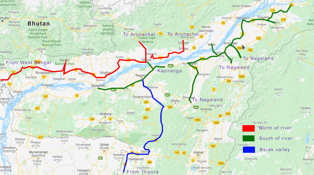
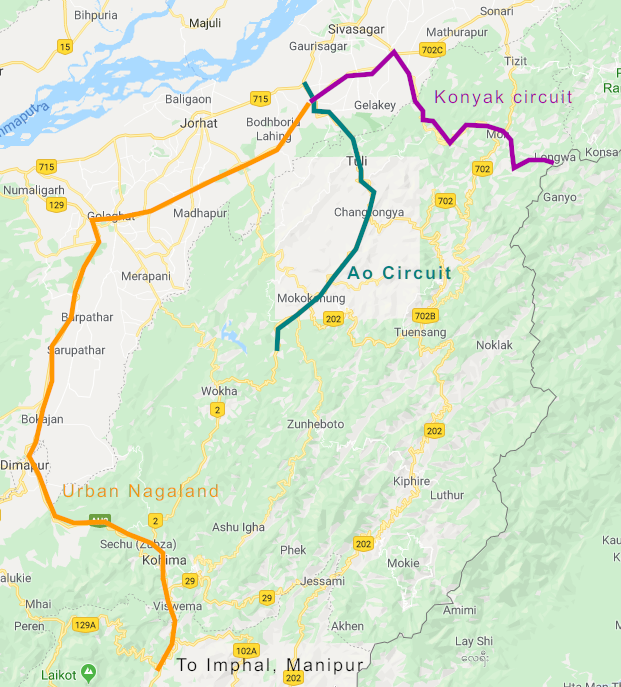
Our route plan
Assam is a state that appears long and thin on the map. The east-to-west territory is significantly longer than the north-to-south. Cutting the already thin north-to-south expanse is the gigantic Brahmaputra river, which at its widest, spans 14 km in its north-to-south breadth.
The region to the north of the river is very thin. Less than 100 km of travel will put you in Arunachal Pradesh or Bhutan. The northern side has only two major cities: New Bongaigaon and Tezpur. There are other towns which are just entry points to different circuits in Arunachal Pradesh, such as Dhemaji, North Lakhimpur and Gohpur. Arunachal Pradesh is the only state that borders north Assam, also locally referred to as upper Assam. There are two national parks, Orang and Manas, on the north side of the river. Two more towns, Nalbari and Rangiya are important highway junctions with access to river bridges that cross the Brahmaputra river to the south side.
The region to the south of the river is broader, twice the span of the north. The south of the river also saw various dynasties such as Ahom and Kamrup. Hence you will see more cities here. Assam’s most happening city Guwahati, second-most important city Dibrugarh, Tinsukia, Sibsagar, Jorhat, Digboi, Lumding and Nagaon are all part of the southern side of the river. The south side also has more national parks such as Kaziranga and Laokhoa. 5 north-eastern states in their entirity can be approached only from south of the river, while Arunachal Pradesh has one entry from this side too. The southern part has a less-explored hilly region with hill stations such as Haflong.
It made perfect sense for us to divide Assam into two sections using the river. Here is how we planned a route.
Click to enlarge
I. North of the river: Ne w Bongaigaon, Barpeta, Manas national park, Nalbari, Orang national park, Tezpur, entire state of Arunachal Pradesh II. South of the river: Dum Duma, Digboi, Tinsukia, Dibrugarh, Sibsagar, Jorhat, 4 north east states (Nagaland, Manipur, Mizoram, Tripura), Lumding, Nagaon, Kaziranga, state of Meghalaya, Guwahati III. Barak valley: Most of Assam is centred around Brahmaputra river. There is another river named Barak, that flows in the south of Assam, where it serves as a natural border to Bangladesh. It is worth checking out the highway between border city Karimganj to Lumding via Silchar that takes you parallel to the Barak river till you reach the hill station, Haflong. We don’t recommend this route unless you have an excellent motorbike with a powerful engine or a four-wheel driven SUV. Most of the time, we had to ride over slush and flowing river beds. Low ground clearance vehicles would have inevitably broken down. 20 months have passed between our trip and our writing this post, so you should check if those highways are in better condition today.
Section I: North of Brahmaputra
Assam to the north of Brahmaputra is a narrow strip of land, where the north-south expanse at some places is less than 50 km, before we reach one of two places: the state of Arunachal Pradesh or the royal country of Bhutan. Here are some things worth seeing in upper Assam.
New Bongaigaon: New Bongaigaon is one of the major cities of Assam state. Its growth is mainly due to Indian Oil Corporation’s refinery. New Bongaigaon is one of the 5 districts in Assam, where you will find more Bengali influence than Assamese. For this city, the Bengali influence is due to being at the border of West Bengal and Assam. Bongaigaon district shares a border with Alipurduar district of West Bengal. In fact our entry to Assam during India 360 was crossing the Gangadhar river on the highway between the two districts. While there aren’t touristy things to see in New Bongaigaon, the city makes a good place to break for the night or for lunch, if you have just crossed the state border or even if you have exited Bhutan via Gelephu.
Barpeta: Barpeta is a town that serves as an entry point to the Manas national park. The park is partly in India and partly in Bhutan, where it is known as the Royal Manas national park.
Tezpur: is a city situated at the confluence of Brahmaputra river with Kameng river. The Indian Air Force has a base a Tezpur. Places of interest at Tezpur are: Brahmaputra river view, Mahabairabh temple, Agnigadh and Tezpur market. Tezpur is also an important road-head for travelling to Tawang district of Assam, along a road that follows the Kameng river. We stayed with close relatives at Tezpur. To the south of Tezpur is a river bridge that crosses to the southern Assamese town of Kaliabor, from where Kaziranga national park is less than 40 km away. Because, we had close relatives at Tezpur, the city formed a place where we could crash after completing different parts of our north-east trip.
Brahmaputra river south of Tezpur
Section II: South of Brahmaputra
We crossed to the south of Brahmaputra in the state of Arunachal Pradesh at Parshuram Kund (see the post How we covered it: Arunachal Pradesh). From there, here is what we covered.
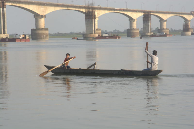
Dum Duma: is a town from where one can access Bhupen Hazarika river bridge, the longest road-over-river bridge in India, spanning 14 km. It is also a highway junction from where it is easy to travel to cities like Digboi and Margherita. We stayed with friends at Rupai, a locality about 3 km from Dum Duma.
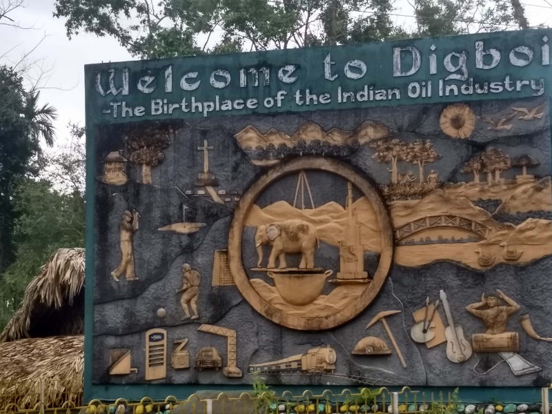
Digboi: is a town where India’s earliest oil refineries were started. During those days, elephants were used as counter weights on pulleys in order to release the oil from the depths of the ground to the surface. The British exploited Digboi more than any other area of Assam, because it was extremely lucrative for them. They used Digboi for oil, tea and timber. Today, Digboi has one of India’s largest oil refineries operated by Assam Oil, a subsidiary of Indian Oil Corporation. You can drive around town enjoying the tea plantations, the Indian Oil township and its Oil museum.
Tinsukia, Dibrugarh: are two cities 40 kilometres apart and form important settlements to the south-east of Assam. Both cities have several tea processing plants and educational hubs.
Sibsagar: is a town that used to be the capital of Ahom dynasty (see the post History revisited: The Ahom dynasty of Sibsagar, Assam). You can see several heritage structures built by the Ahom dynasty around Sibsagar such as the Shiva Dhol, Devi Dhol, Vishnu Dhol, Rang Ghar and Talatal Ghar.
Shiva Dhol, which was built by the Ahom dynasty at Sibsagar
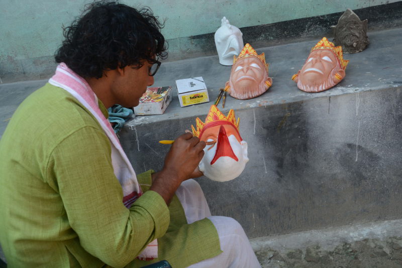
Jorhat & Majuli: Jorhat is a town that serves as the ferry point for exploring Majuli island. Majuli is the largest river island in the world. Majuli is divided into regions called Satras. Each Satra is carved out based on the chief occupation of the people of the Satra. E.g. Samaguri Satra is for making masks, Solmara is for pottery, etc. Auniati Satra is the religious and cultural hub of Majuli. In Majuli, one can stay in one of the several homestays or cottages, most of which also comes with food. A good way to explore Majuli is by hiring a bicycle.
Mask making at Samaguri Satra, Majuli
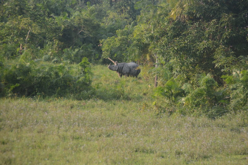
Kaziranga National Park: is India’s most famous national park for spotting one-horned rhinoceros. This park has the highest number and density of rhinos. One can take a jeep safari inside the park. But it is also possible to spot rhinos at the edge of the park on the highway between Nagaon to Jorhat, from a place called the rhino view point. Besides rhinos, Kaziranga also has tigers, leopards, water buffaloes, several species of deer and bird life.
Rhino spotted from the Guwahati – Nagaon – Jorhat highway at the edge of Kaziranga national park. This shot is very lucky. Due to rhino’s aggressive nature, even jeep safaris keep this amount of distance from them. We got this shot for free from the highway without having to pay for a safari!
Guwahati: is the most happening city of Assam. Within Guwahati is a seperate enclave with is own corporation. This enclave is named Dispur and is officially the capital of Assam. Guwahati is famous for Kamakhya temple, silk museum, several institutes, and a beautiful Brahmaputra river cruise.
Section III: Barak valley
Barak valley is a route that follows the Barak river from the hill station of Haflong to the point where the river enters Bangladesh near the state of Tripura. The only major cities on the route are near the Bangladeshi border, i.e. Karimganj and Silchar, both of which are Bengali speaking due to their proximity to Bangladesh. Along the way there are stunning views of the river, the rail route that connects Lumding to Agartala via Silchar and the view of forested hills in every direction. The smaller rivers from the hills, on the way to joining the Barak river, form streams and waterfalls along the way.
Barak river at Karimganj. Across the river is Bangladesh.
While stunning in beauty, the road is full of slush, loose rocks and mud. Some rivers have also overflown and knocked down some of the bridges. Such rivers flow dangerously on the road. The route is not for the faint-hearted or those with ill-prepared vehicles. Barak valley road was our most challenging motorbike ride segment in all of India 360. But once you reach Haflong, you cross a tunnel. On the other side of the tunnel, a different world awaits. The road turns into a 3-lanes-a-side fully paved high-speed national highway. You will reach Lumding and then Nagaon in no time.
Conclusion
Assam is a fairly easy state to plan your route. But there is so much in the state that is undiscovered and not well-documented. You are suggested to spend some time on TripAdvisor and also speak to the locals about what is unique to their area. You will discover plenty of hidden gems.
In the last post, Travel Tips: Everything you need to know about camping in India: Part 1, we saw what camping in India really takes. We saw the effects of weather, the problems with nature’s call and the fact that camping on your own is not the same as going with an organisation that set up the camping for you. If that post didn’t dissuade you from camping on your own and in fact fired you up, then this post is for you. We will give you guidelines on how to prepare and what to carry.
Tip #1: Camping Gears: Try it out for cheap by renting
Before you buy all the equipment needed for camping, you may consider giving camping by self a trial and see if it really is for you. Most people start with high hopes, but find that camping on their own is tricky. The costly tents they purchased are now lying in their attic, while they prefer to go with organisations that set up camps.
In our opinion, you should rent camping equipment during your first outing. In Mumbai, we know a shop in Dadar locality that gives out equipment for rent. Similar equipment may be available for rent in cities like Pune and Bengaluru that are surrounded by hills and forests. Adventure equipment shops in towns like Uttarkashi, Mussoorie and Loharjung in Uttarakhand also give out equipment for rent.
Along with tents, you can rent other equipment like gas canisters, torches, ropes and shoes. If you are from Mumbai / Pune, you can also rent online at Bragpacker.com. Residents of other cities can check out 10kya.com
Tip #2: Camping Tents: Firmly decide the number of persons for your trip
Indecisiveness can throw your planning out of gear. Image source: Amazon.com
Getting the number of persons for your trip correct is a major problem, especially if you are among a group of people who keep changing their minds. Organisations like YHAI make it easy on themselves by deciding batch sizes and taking in reservations. They already know the maximum number of people per batch. If people do not turn up, they still carry spare tents and food as reserves, since they already have hired porters for maximum capacity. The opposite problem of taking in too much people does not arise because they take in reservations for their treks.
The number of people for the trip determines how many tents & sleeping bags you’ll carry, how much food you’ll haul and the mode of transport you’ll take to your destination. It is always safer to err on the higher side. For instance, if you planned for 7 persons and only 5 turn up, that’s fine. But if you plan for 5 persons and 7 turn up, then you have a problem. Two persons need to be crammed into the available tents and the food also needs to get split into smaller portions.
For a group that’s indecisive, it is better to let each person buy their own equipment, such as a one-man tent, and carry their own food, rather than ordering catered food for everyone.
For India 360, the number of persons was always 2. We didn’t camp with anyone else, although we had several travel companions at several places. 🙂
Tip #3: Camping Equipments: Get the smallest and cheapest equipment you can
When you start camping, do not go for high end equipment that is used by professionals. There is no need to splurge for what will just be a hobby during weekends or during short to medium term travels, with the costs borne by you. Start with a one, two or a three-man tent by Quechua, the brand that is attempting to bring adventure at an affordable price to the people of India. You can pick up really good tents for really economical prices from Decathlon outlets. Cities like Mumbai, Bengaluru, Delhi, Chennai, Kolkata, Hyderabad, Ahmedabad and Pune have multiple Decathlon outlets, one of them probably close to you. Otherwise, they have an online shop that delivers around India. Amazon India also stocks Quechua products.
You can find similar deals for sleeping bags, shoes, rucksacks, backpacks and dri-fit clothes.
Tip #4: Camping anD hiking: Pack smart
A well-packed backpack / rucksack should stay upright without support and should not tilt to any side.
Your sleeping bag should always go to the bottom of your rucksack / backpack. It should be plush against your lower back. Other heavy items also go near the bottom of the bag on top of the sleeping bag. After your heavy items are done, pack things in order of priority in which you might take them out during your trek / travel. Items take out more often, such as sun glasses, caps, gloves, bandana, dry food, etc, should be at the top of your backpack or preferably even in a seperate compartment of your bag. Your tent usually straps to the side of your backpack and is tied by a strap or an elastic rope. Further down in your backpack should only be items that you’ll need when you camp.
After packing, make the backpack stand on the floor with no support. If it tilts to one side or away from where your back would be, then you have packed it unevenly and you need to redistribute. If it tilts such that it would lean on you, then that’s not a problem.
Packing smart is actually a checklist that goes A-B-C. The letter B stands for balance and is achieved when you pack your backpack such that it will willingly stand on the floor. A for accessibility, which means that you will be able to fish frequently used items from the top of the backpack, without having to rummage into the depths of it. C stands for compression and we’ll come to that point when we discuss ranger rolling.
Tip #4: camping bag: Get the right backpack
You need a backpack with good adjustments. Your go-to bag should be 50 to 60 litres, while you should have a 15 litre bag folded and packed just in case you need to explore some spots around your camping site. The backpack should have enough straps such that you can yank and pull at them to create various measures of tightness and looseness. You should be able to tighten it enough so that it sits firmly against your back. You shouldn’t be able to slide your hand between your back and the backpack. At the same time you should also be able to loosen the bag, so that you don’t have to do multiple shrugs to get it on your shoulders in the first place. Nor should you have to struggle to shrug it off your back when you reach your campsite.
The correct way to get a backpack on your back is to loosen the straps and slide each of your hands into each strap, such that the straps sit on the elbows. Once both the elbows have one strap each, you heave just once and the backpack should automatically jump to your shoulders. Thereafter, you tighten each strap until the bag sits against your back firmly. Never get one strap all the way upto one shoulder. This leads to comical and uncomfortable episodes where you are trying to wiggle your other hand into the other strap and tumbling around.
Tip #5: Camping to DO: Learn to ranger roll
Ranger rolling is way to pack clothes for trekking and camping. It involves creating pockets within the folds of clothes so that the item tucks into itself and does not unravel. The space occupied by ranger-rolled clothes is incredibly smaller compared to that by folded clothes.
Tip #6: camping Accessories: Always carry a steel plate, spoon and mug… and a sponge
Disposable plates, cups and spoons should be AVOIDED as much as possible. You should always carry a steel plate, spoon and mug for your camp meals. You should be able to wash them after use with water in a nearby lake, stream or pond. Also, never dump steel utensils directly in water bodies, unless it is fast flowing. You should wet a sponge and wipe your steel utensils clean. Mud is usually a good scouring agent and can be coated lightly on the plates before wiping them.
As a promise, also try to avoid anything that comes in a paper or plastic wrapper if you can and carry things in airtight boxes such as Tupperware. Granola bars and dry food can be taken out of their wrappers and stored in airtight boxes that can be carried in your backpack. Problems happen when you have wet or gooey food items like chocolates and juice in pouches and cartons. In this case, completely unfurl the plastic and carton and scoop every last bit / drop with your spoon and finish the item. Once clean of residue, the wrappers / cartons can be dumped into your back pack. If you are carrying a seperate food bag, then put all the paper and plastic waste right back in it as you carry it back to the city.
REMEMBER: No dumping paper, food or plastic waste in camping sites…… EVER! We repeat. Do not EVER dump rubbish in any camping site. Leave the world a better place than how you found it. At least leave it the same. Never deteriorate a naturally beautiful place with all your urban waste.
Tip #7: Basic tent pitching in camping sites
We have already mentioned in the last post that camping should ideally be on short grass or a surface with earth / sand. The first layer that goes on is a sheet of tarpoline. The tarp sheet keeps the floor of the tent dry, should it rain or snow. Next comes the process of laying the tent flat on the tarp. Smooth out all the kinks and creases. Tents usually have a couple of fibre glass poles that form the skeleton. The skeletons go through designated slots on the tent walls. The poles are in in form of segments joined end to end by slotting the notch at one of a segment to the corresponding hole in another segment. The assembled pole can be bent to a semicircular or parabolic shape. This shape is what keeps the structure of the tent after it is pitched.
After the tent is standing, it is time to secure the nylon ropes to the designated loops on the tent wall. The other ends of the ropes are tied to ‘pitons’ or steel rods that drive into the grass or earth. The pitons are stakes in the ground and prevent the tent from flying away if the ropes are tied securely. If the ground is hard and the pitons cannot be driven in, then you can find heavy stones or rocks that you can tie your nylon ropes to.
Two fibre glass poles are passed through slots in the tent’s fabric. The poles hold the tent in its shape. The tent is held in place by the four nylon ropes whose ends are tied to loops in the tent’s wall and also to steel pitons staked to the grass. Our heavy luggage did the rest.
With this, the tent should last the night. It is time to dump your heavy backpacks and sleeping bags into the tent. Leave your shoes outside the entry flap of the tent and also keep a pair of slippers that you can use to walk around the campsite. Once you get inside, the combined weight of the backpacks, the sleeping bags and your body will keep the tent securely in place. At least ‘All izz well’ inside the tent, no matter what happens outside.
Here is a video on pitching a typical Quechua Arpenaz tent.
Tip #8: Try your tent and sleeping bag in your apartment hall / backyard / lawn first
Practising tent pitching at the hall of our Thane apartment.
You do not want to be fumbling with instructions on a camping site in fading light, wind, rain or snow. Always try pitching a tent in a known place such as your bedroom, hall, balcony, backyard, porch or lawn. Practise it twice.. and then more. Practise until it becomes familiar. Assemble and take down the tent again and again. Unroll and roll your sleeping bag as many times as you feel is necessary for practice.
Can our pitched tent take some baby mischief? We invited our nephew and niece inside the tent while practising pitching at their parents’ home in Assam. The niece is clearly claustrophobic and wants out 😀
Tip #9: camping food: Avoid cooking during your first few camping trips
Since packing for camping is already daunting, you do not want to make it more complicated by carrying raw food ingredients, a fairly heavy gas canister and a cooking stove. I strongly advise you against using firewood. It is hard to light a pile of firewood anyway. Also, it is not a good idea to cut fresh wood from trees and use them as fuel. Do not cause your own mini-deforestation. Using dry wood and twigs is fine, but you don’t want to gather firewood if you don’t know how to do it the right way. A gas canister and stove save you that trouble.
But all troubles are solved when you buy food along the way or prepare it before the trip. Take as much dry food as you can. On a multi-day camp, wet items like gravies, fresh fruits and fresh vegetables will spoil quickly. Drier items like granola bars, dry fruits and baked vegetable chips last longer. So do roasted, toasted and fried items like theplas, mathris, papads, tortillas, nachos and mixtures. Vegetables last longer if they are pickled.
Tip #10: camping clothes: Pack a seperate set of clothes for your activities and for camping
You should always have one dry set of attire that you wear within the camp site inside your tent. This set is to keep you dry. It also keeps you warm if you camp in cold places. Never wear that set for activities like trekking, travelling, enjoying waterfalls, etc. Just like you have your day clothes and then pyjamas / nighties for your city life, you should have two sets for camping too.
In cold weather, your woollen socks, thermals, woollen gloves, woollen caps and dry tees and pants should make up your night dress. During the day, even in cold weather, you’ll use dri-fits and cotton. Through the course of your activity, your body will generate warmth. If you are out in the snow, you’ll need a fleece jacket, woollen gloves, woollen cap and a layer of woollen socks over your cotton socks. But that woollen set should not be the same that you wear for the night. Those will get wet in rain and snow and shouldn’t be used while sleeping.
Also, your night set should be packed in two layers of plastic or any other waterproof material to keep them from getting wet, even if your backpack gets wet.
Tip #11: Your water intake
Avoid plastic or glass bottles. Your best bet is to take a sturdy steel sipper that won’t easily crack or get dented. If your camping is also accompanied by activities like trekking, then we suggest you to buy a ‘hydration pouch‘, which is a leak-proof pouch that can hold 1 or 2 litres of water. A pipe with a valve is attached to the pouch. Instead of getting your backpack off to take your water sipper, you can leave a hydration pouch within your backpack, but keep sipping the water from the pipe after releasing its valve. When you are done sipping, you can close the valve. This is also useful to have a sip of water while lying down, say when you wake up from your sleep in the middle of the night to drink some water and intend to go back to sleep again.
Tip #12: Wet wipes, dry wipes, paper soap and hand sanitiser
Carry an assortment of wet tissues, dry tissues, paper soap and a hand sanitiser fluid. These come in handy when you attend nature’s call or also when you get your hands dirty, such as when pitching your tent. Remember to collect your used paper soap in the same bag compartment where you are keeping all your other discardables (plastic wrappers, paper pouches, etc). A spritz of hand sanitiser fluid disinfects your hands before you touch your food.
Tips #13: what do you need for camping? : Your minimum luggage
While there are several things you can carry for camping, some of them essential and some of them unnecessary & even weird (we saw a girl carry her hair spray and use it at the campsite!), here are the things that you should have at a minimum. These are in order of importance.
Tent with its kit and tarpoline sheet. This is priority #1 since you are camping on your own.
Water bottle or water pouch
Wallet with cash (make sure you have CASH, since remote places have no networks for either card machines or digital wallets to work)
Wet tissue, dry tissue, paper soap, hand sanitiser
Torch
For a battery-operated torch, carry extra batteries.
For a torch with a solar charged battery, please make sure that the torch is fully charged by dusk. You can hand it on the outside of your backpack during the day, where it catches the sun.
The best types of torches for camping overnight are the ones with a hand-operated crank. You whirl or press a crank attached to the torch and it gets charged by the kinetic energy. You may need to rotate / press the crank about 500 – 600 times to charge the torch completely so that it lasts the night. Makes for a good hand workout. Delegate the cranking among other campers too.
Backpack / rucksack. Why is this as low as point #8? Well, you don’t need a backpack if you have driven to your campsite and intend to leave your stuff in the car until the next morning.
Sleeping bag. A sleeping bag is not strictly necessary if you are camping during monsoon in the Western Ghats. That’s why we have it as point #9. If you are camping in the Himalayas, this would be point #2, right after tent. But contrary to what is advertised all the time, we don’t want to project that camping in India is all about being in the Himalayas. You can camp in forests, grasslands, riversides, lakesides, beaches, mountain tops, mountain caves (the last three are particularly popular in Maharashtra), outskirts of villages or even in plain areas near national highways all around the country, be it warm plains or freezing mountains.
For warm areas, you can carry an inflatable mattress or an air pillow instead of a sleeping bag.
Separate dry clothes inside a waterproof bag for wearing at the campsite
Dry food or long-lasting food. Not required if your campsite is a short distance away from restaurants or kitchens.
Steel plate, spoon, mug
Slippers for the campsite, preferably in the form of loafer socks, i.e. socks cum slipper
Camera, tripod, selfie-stick. Please note that selfie-sticks are not just for selfies. They can take photos from interesting angles without you being part of the photo.
Plenty of episodes of your favourite TV / Internet series downloaded to your phone for offline watching. Even we have lost count of the number of episodes of Mentalist and Elementary that we watched during our India 360 camping days. This is useful for insomniacs. But then also carry a headset / earphone, so that you don’t disturb your tent-mate / neighbouring tents
Tip #14: cAmping Fun
Fun Camping in Malshej Ghat !!
Camping on your own entails a lot of mental and physical exertion. It is easy to get diverted away from the natural beauty of the place you have chosen to camp. It is easy to get caught up in the whirlwind of activity around camping on your own. Pitching a tent reliably, unpacking and serving food, cleaning your utensils, taking care of garbage, setting up your sleeping bag, unpacking and packing your backpack and keeping everything safe for the night. But you have to take breathers and enjoy the moment and your surroundings.
Conclusion
Camping on your own needs a lot of preparation. It needs attention to detail and prioritising the right things. It needs the right place, right weather and the right person to do it with. But once you get a hang of it, you’ll be hooked. Even if you like going with a company that sets up camping for you, you’ll never get the same satisfaction that you derive from packing for a camping trip, planning your camping spot, pitching a tent and jumping into one that was set up with your own effort. You should definitely give it a try. Happy camping.
Just like Chhatrapati Shivaji for Marathas, Akbar for Mughals and Krishna Devaraya for Vijayanagara, the rule of Rajaraja Chozhan is considered to be a golden period for Tamil Nadu’s Chozha empire (also spelt as Chola empire). Thanjavur or Tanjore was the capital of the Chozhas for a long time and it flourished particularly during the rule of Rajaraja Chozhan. After a short period of uncertainty, the city underwent another cultural renaissance during the rule of the Maratha king Serfoji II. While Rajaraja Chozhan’s time was good for Tamil literature and Chozha architecture, Sanskrit was the main focus of Serfoji II.
Let’s learn more about one of India’s most ancient cities.
Geography of Thanjavur
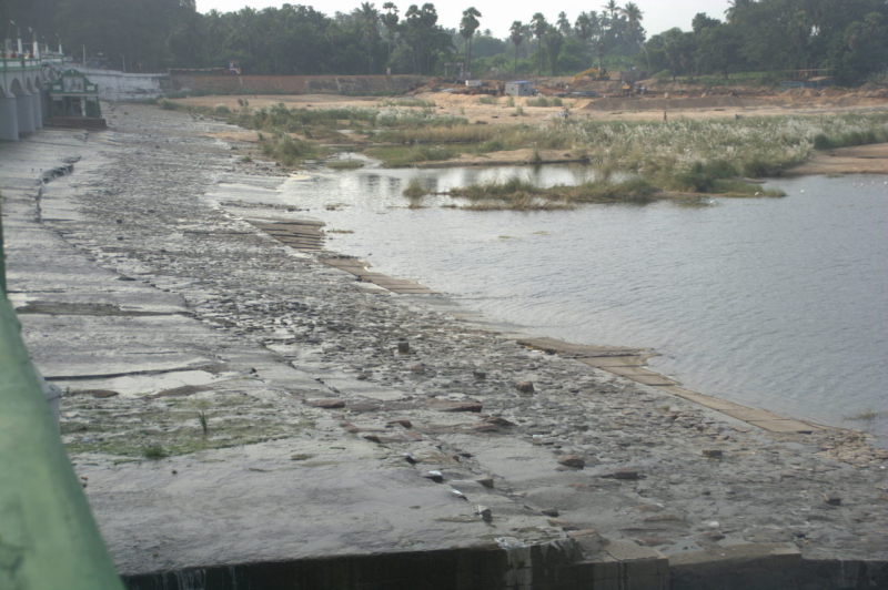
Thanjavur is the headquarters of the district of the same name. The city is to the south of the five rivers that diverge from Cauvery river to the east of India’s oldest dam — Kallanai or Grand Anicut. The rivers are Kollidam, Cauvery itself, Kudamurutti, Kuruvadi and Vennar. The southern-most of the five, Vennar river is the closest to Thanjavur city.
Thus Thanjavur is part of a very fertile plain. Along with neighbouring Trichy (Thiruchirapally) district, Thanjavur district is one of the biggest contributors to Tamil Nadu’s agriculture sector. For this, both the districts have Cauvery river system to thank.
The land around Thanjavur is flat and one can see no hills or even undulations for several kilometres.
People of Thanjavur
The majority of Thanjavur city is populated by Tamil-speaking Hindus, mainly belonging to the Paraiyar and Vanniyar castes. Most of the people are employed in agriculture, government jobs, medicine, teaching and in private industries that mostly cater to agriculture, such as production of fertilisers, production of irrigation pipes, sugar extraction, husking, etc.
A small section of people in Thanjavur city are descendents of the Maratha rulers and their subjects. While fluent in Tamil, among their own they speak a dialect of Marathi which sounds significantly different from the one spoken in Maharashtra, north Goa and north Karnataka. But because of this option, several contractors from Maharashtra take up temporary work in Thanjavur.
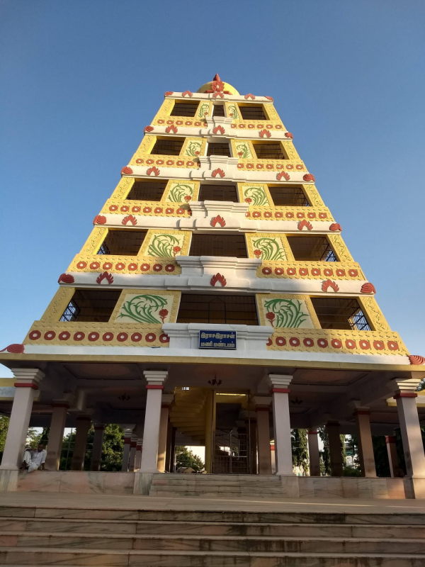
Here are the best places to see in Thanjavur city.
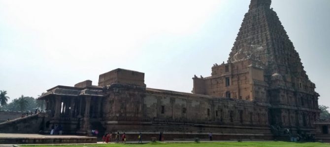
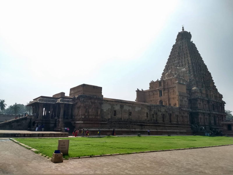
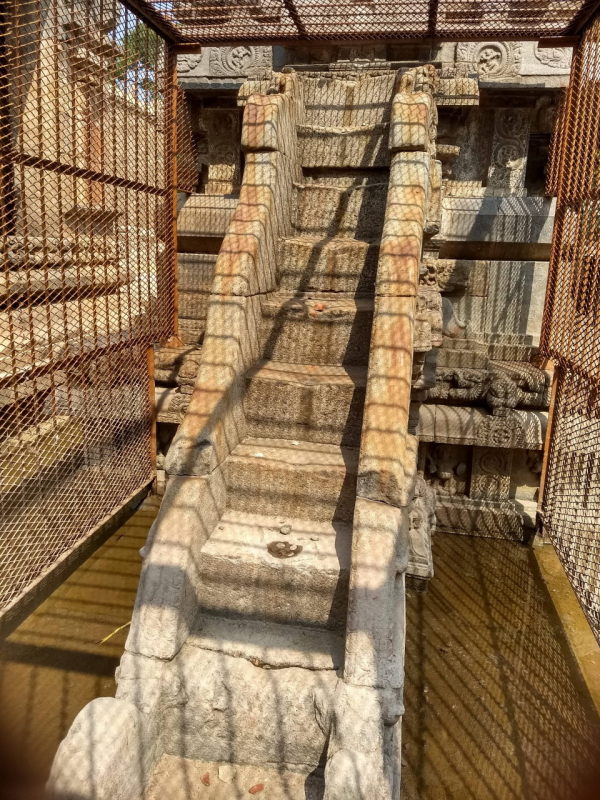
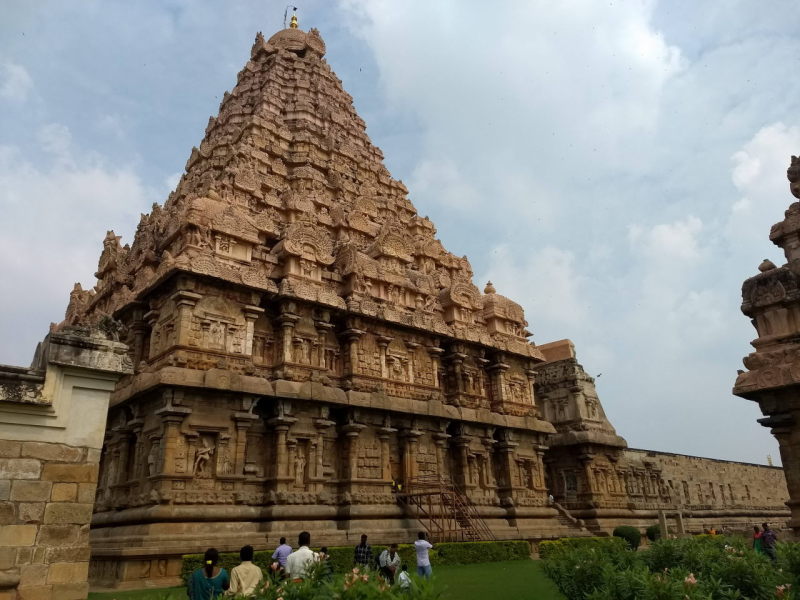
Brihadeeshwara temple
Brihadeeshwara temple is the crowning glory of Thanjavur. It is one of the largest temples in India. The temple is one of the main reasons for Thanjavur to flourish as a tourist centre in Tamil Nadu. Brihadeeshwara temple is a UNESCO world heritage structure.
Brihadheeshwara temple
The temple was built during the time of Chozha emperor considered to be the greatest in the dynasty — Rajaraja Chozhan. The temple is also referred to as Rajarajeshwaram. The temple was finished in 1010 AD.
The vimana (main dome) of the temple is an extremely tall 16-storey tapering structure reaching a height of 66 metres (220 feet). The base of the vimana sits on an massive 30 sqm or 100 sqft base. Inside the vimana is the largest monolithic Shiva Linga in the world, measuring 8.7 metres (29 feet) in height. Hence the name Brihadeeshwara (the huge Lord).
The temple sits on a massive courtyard, thus making it the largest temple complex including only temple facilities, in the world. It ranks second behind Srirangam temple of Trichy in terms of area inside temple perimeter, but Srirangam includes the town and the residential area itself inside the temple gates.
Please note that similar to many major Tamil Nadu temples, the main sanctum is closed to public for darshan from 12 pm to 4 pm. So plan a visit either in the morning or in the evening. The temple gates and the courtyard complex remain open during those 4 hours.
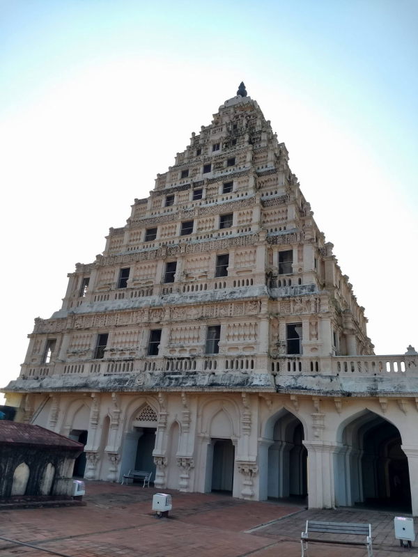
Thanjavur palace
Thanjavur palace is the palace of the Maratha kingdom that ruled Thanjavur. The palace was built during the rule of Venkoji, who started the southern Maratha kingdom. Venkoji was a half-brother (brother through another mother) of Chhatrapati Shivaji, the most influential Maratha ruler. After an uncertain period for the Marathas which including plenty of turmoil with the neighbouring kingdoms and foreign invaders, king Serfoji II signed a peace treaty with the British, that forfeited all of Marathas’s conquests to the British, except for Thanjavur district remained under Serfoji II. With peace restored, Thanjavur was able to focus on literature and art yet again, and was peaceful until the annexation by the British in 1800.
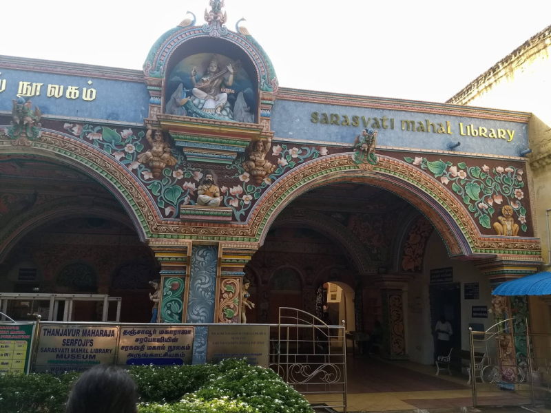
Inside Thanjavur palace
The period of peace was a good one for the palace, especially for the palace’s main highlight, the Saraswati Mahal. This is the royal library that has nearly 50,000 volumes, some of them older than 1000 years. The library has collections from the time when paper was not used as a medium. There are collections in palm leaves and papyrus. The majority of the collection is in Tamil, followed by Sanskrit. The rest are collections written in languages no longer used in India, such as Pali, Magadhi, etc.
Saraswati Mahal library inside Thanjavur palace
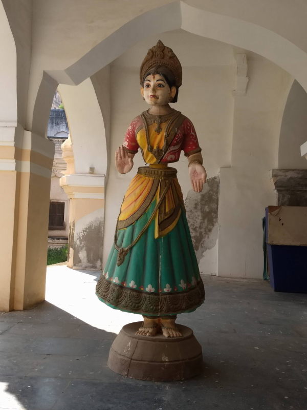
Besides the library, the palace has other points of interest, such as the durbar hall with a statue of Serfoji II, open terraces, a central courtyard and a couple of museums. The museums show traditional Thanjavur artefacts such as the Thanjavur dancing doll and Thanjavur decorative plate.
A Thanjavur dancing doll. The neck keeps moving from side to side.
Mani Mandapam
Rajaraja Chozhan Manimandapam, which is also Rajaraja Chozhan museum
Towards the southern end of the city is a triangular park with a tower dedicated to Rajaraja Chozhan. The tower is 5 storeys high and tapering. The park itself has a statue of Rajaraja Chozhan sitting on a prancing horse. At the base of the tower is a museum showcasing Chozha architecture and their lineage.
Also around Thanjavur
It takes a complete sight-seeing day or even two to explore the Brihadeeshwara temple, Maratha palace and Mani Mandapam. But while you are staying at Thanjavur, you can take the opportunity to see some other places of interest, all of them within 50 km of Thanjavur, but in various directions.
Kallanai / Grand Anicut: is India’s first dam built on a river. The dam was built with stones during the time of Karikaalan Chozhan, the king who ruled the dynasty around 0 AD. The dam was built using the strength of several elephants.
Grand Anicut, one of the world’s first dams.
The dam is on the highway between Thanjavur and Trichy. So if you are headed to Thanjavur from Trichy (like we were), then you get to see this dam before reaching Thanjavur.
Thiruvaiyyaru: The name Thiruvaiyyaru can be broken down as ‘Thiru ai aaru’, which means the ‘five holy rivers’ in Tamil. Read the geography section of this post to learn more about the 5 rivers. This village itself is famous as the town where the Carnatic song composer Thyagaraja sat by the Vennar river and wrote Telugu songs mostly as a devotee of Lord Rama. Every year on Thyagaraja’s birthday as per the Hindu calendar, Carnatic music’s most famous practitioners assemble at the hall of what was once Thyagaraja’s house and recite the songs composed by him. These songs are referred to as ‘Kriti’s.
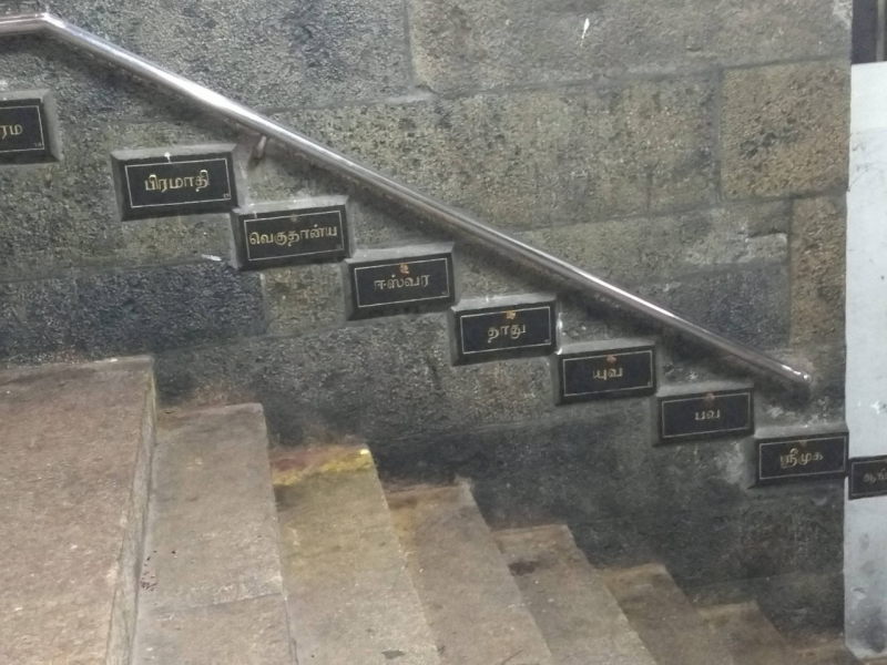
Swami Malai: On the highway between Thanjavur and Kumbakkonam, just 8 km before the latter, is the temple of Swami Malai, a temple dedicated to Lord Murugan. Swami Malai is one of the six ‘Aruppadai Veedu’s or ‘the six abodes of the Lord’. An interesting thing to observe in Swami Malai is the sixty steps on the stair case that lead to the sanctum. Just like the Chinese calendar repeats in a cycle of twelve years, each year dedicated to an animal (e.g. the pig year, the dragon year, etc), the Tamil calendar repeats in a cycle of sixty years, with each year given a name. Each name repeats once every 60 years. One complete cycle involving sixty years is known as a ‘Sangamam’. In Tamil Nadu, a person who turns sixty is celebrated with a ceremony, since he/she has seen one complete Sangamam.
The Tamil Sangamam year names are written beside each step. From top to bottom in this photo are: Bramhadi, Vegudhanya, Ishwara, Naadhu, Yuva, Bhava and Shrimukha.
Kumbakkonam: is a city about 50 km from Thanjavur, known for its various temples. Almost every locality in the city has one major historic temple. The city was built during the time of Rajaraja Chozhan and several temples were later added by successive rulers. At the centre of the town is a pond called the Mahamahan tank, where a festival happens every 12 years. During this festival, people from around Tamil Nadu take a bath in the holy pond to wash off their sins.
Dharasuran: is a village near Kumbakkonam and is home to the Airawateshwara temple, another temple with Chozha architecture. Of particular interest in this temple is the staircase of seven tunes or the ‘Sapta Swara’. Tapping or stomping on the stairs makes sounds, each of them in tune with the Indian musical scale ‘Sa Re Ga Ma Pa Da Ni’. Unfortunately, due to structural damage, these stairs have been fenced off and are now closed to public.
The musical steps, sadly fenced off from the public.
Thiruvarur: was the capital of the Chozha empire during the time of Kulothungan I. It is famous for the Thyagaraja temple, a Shiva temple. The holy trinity of Carnatic music, the three composers, Shyama Shastri, Thyagaraja and Muthuswami Dikshithar, were all born in Thiruvarur. An annual temple chariot festival is held at Thiruvarur every April. The chariot is the largest and heaviest in Tamil Nadu.
Gangaikonda Chozhapuram: Rajendra Chozhan I defeated the Pala dynasty in present day Bihar, Jharkhand and West Bengal. In victory, he collected some water from river Ganga. After his return, he constructed another Brihadeeshwara temple in a town about 70 km north-east of Thanjavur and to the north of Kollidam river, the northern-most of the five. The new temple was also called Brihadeeshwara temple, and the new town, that served as a capital, was named Gangaikonda Chozhapuram or ‘the town of the Chozha who won over Ganga’. Similar to Thanjavur temple, Gangaikonda Chozhapuram temple is also a UNESCO world heritage.
At Gangai Konda Cholapuram
Reaching Thanjavur city
Air: Thanjavur has an airstrip used by the Indian Air Force, but there are no commercial flights. The nearest airport is at Trichy with flights to major cities all over India, the most connected of them being Chennai and Bengaluru.
Rail: Thanjavur Jn is a railway station in the Southern Railway zone’s Trichy division, but is not on a frequently used route. There are two train routes on the route Chennai – Villupuram – Trichy – Madurai. One of them, the ‘main’ line is actually no longer the preferred route. Between Villupuram and Trichy on the main route, we come across several towns such as Neyveli, Chidambaram, Mayiladuthurai (Mayavaram), Kumbakkonam and Thanjavur before reaching Trichy. But because of dense population and the presence of several towns, the speed limit on the route is restricted.
Another route between Villupuram and Trichy is the the chord route, which is straighter, shorter and faster, with only one town, Virudhachalam on the way. Super fast express trains like Pandian Express, Vaigai Express, Duronto and Sampark Kranti prefer this route. The running time is two and a half hours shorter than the main route.
The main route, that passes through Thanjavur, is less favoured by the railways and used by slower trains and passengers. It’s advisable to check the train timetable to decide between a train that covers Thanjavur or rather a super-fast train from which you can alight at Trichy and take a bus to Thanjavur (40 km bus trip). The latter may actually save you time.
Road: Thanjavur is a major bus depot in Tamil Nadu. It is connected to all major cities, with the frequency of buses being particularly high for Trichy and Chennai. One can reach either of the two cities by air or rail and take a bus to Thanjavur.
Self-drive: If you are driving from the east of India, e.g. from north-eastern states, Assam, West Bengal, Odisha or Andhra Pradesh, then you should reach Chennai by joining the Kolkata – Bhubaneshwar – Vishakhapatnam – Rajahmundry – Vijayawada – Nellore – Guduru – Chennai coromandel route. Thereafter, you should use the GST (Grand State Trunk) highway via Chennai – Tindivanam – Villupuram – Ulundurpettai – Perambalur – Trichy highway. From Trichy, take the Trichy – Thanjavur highway.
If you are driving from Kerala, then take one of the following routes: Palghat – Coimbatore, Thrissur – Athirapally – Valparai – Pollachi – Coimbatore, Munnar – Theni – Dindigul. Trichy is about an hour from Dindigul, with both cities being part of Grand State Trunk Chennai – Madurai highway. From Coimbatore, you can use the Coimbatore – Tiruppur – Erode – Karur – Trichy highway. Having reached Trichy, you can drive to Thanjavur on the highway connecting the two cities.
From anywhere else in India, you should join the NH4, i.e. Mumbai – Pune – Satara – Kolhapur – Belagavi – Hubballi – Bengaluru – Hosur – Krishnagiri – Vellore – Kanchipuram – Chennai highway. E.g. People from north India / Delhi / Chandigarh can join at Pune or Mumbai. People from Karnataka can join at Hubballi or Bengaluru. The highway ends at Chennai, but you needn’t go there. Instead, take a detour from Hosur to take the following highways one by one: Hosur – Dharmapuri – Salem, Salem – Namakkal – Karur, Karur – Trichy, Trichy – Thanjavur.
Conclusion
Thanjavur is one of the most ancient cities in India, with its glorious days being during the rule of the Chozhas. After some turmoil, a second innings happened during the rule of the Marathas. Thanjavur continues to be an important city today, with high quality engineering and medical colleges and an Indian Army airstrip. But no other time was greater than the one with the Chozhas. You can travel back in time with just one look at the Brihadeeshwara temple.
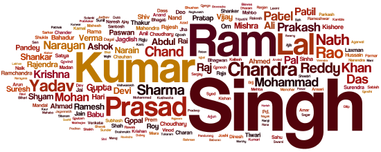
India is a vast country with 29 states and 7 union territories. More than 20 official languages are spoken around the country. If you are Indian, your name is either an ancient Sanskrit, Urdu or Persian word. It may even have a regional etimology, like say names specific to Tamil Nadu, names of Burmese kings or names of deities of regional tribes. The Roman script was introduced to India only in the 15th century, by the Portuguese, who were the first to colonise a large swath of the western part of the country. The English language, that also uses the Roman script, also called alphabets, was only introduced in early 17th century. The world’s most widely spoken language has its roots in European languages like ancient French and Latin. Its system of writing and pronunciation is widely different from and often inadequate for Sanskrit or Urdu. However, with an attempt to standardise English as a business / official language across India and for opportunities abroad, India has widespread English education. Most government documents in India whether online or in paper form are in English in addition to the regional language. English is the most widely used language to fill up forms for procuring government documents. Forms from private enterprises, especially those with a business online, are almost exclusively in English.
Over the last 100 years or so, Indians have comfortably adopted English spellings for their names. Attempts have been made to use a combination of English letters to represent regional sounds not available in English. While most states agree upon almost standard spellings for a lot of names, a whole bunch of names have ambiguous spellings, with all the forms seeming and sounding correct. Add to it the regional differences in pronunciation and your name may have 20 to 30 different English spellings which are lexically correct.
Why you should care
For some sadistic reason, bureaucratics, both in government and private organisations of India, never copy your name exactly as you write in on a paper form. Also, they never copy-paste your name from one computerised form to another. They derive pleasure in re-writing and re-typing your name from scratch, along with their own regional tweaks. Don’t ask us why. As natives of this country, we too are puzzled. It suffices to say that your name will never be reproduced in a bureaucratic document exactly as you submitted it.
The stakes of a most spelling mismatches are low. A bus conductor or a train ticket examiner will let you off the hook, understanding that regional spelling differences are common in India. But when you approach areas with police or army, you may be questioned. Although unlikely that your entry is denied, the job of the police and the army is to be paranoid rather than be accomodative. You don’t want to take chances. After all, you do not want to miss an opportunity to visit exotic places just because a bureaucrat was careless and spelt your name differently on a permit from what your identity proof says.
It pays to check, double-check, even triple-check. You have been warned!
Some unspoken standards
Some combinations and substitutions are nearly standard. All of India agrees upon certain combinations of letters for certain sounds. E.g. the letter ‘c’ is almost never used other than to represent a ‘ch’ pronunciation. To represent the ‘k’-like sound, the letter ‘k’ is always used. You always spell ‘Kumar’ and not ‘Cumar’. Likewise, letter ‘c’ is never used for the the ‘s’-like sound that it brings to the word ‘centre’. Lord Rama’s wife’s name may be spelt as ‘Seeta’ or ‘Sita’, but never as ‘Ceeta’.
Other unspoken standards are: It’s always Jigna and never Gigna. It is always Fahad, never Phahad.
Let’s look at some forms of spelling mismatches that can occur in different regions in India and why they occur.
Western India: Maharashtra, Gujarat and Goa
Convention: There is a symbol ऋ in Devnagari script that the above-mentioned states pronounce and spell as ‘ru’. This letter combination is the closer to the classical Sanskrit pronunciation of that symbol than the way the rest of India spells it, i.e. ‘ri’. Effect: If you are from the north of India with a name such as Rishikesh, Tripti or Rishabh, your name will be spelt in western India as Rushikesh, Trupti and Rushabh.
Convention: If a Devanagari name has a consonant as a standalone, rather than being joined with another consonant, then an extra letter ‘a’ is added to the English spelling. This is a rather complicated concept, but an example will clarify. Effect: A north Indian name that is spelt as Mansi (मानसी in Devnagari) or Janki (जानकी) in north India, will be spelt as Manasi and Janaki in western India. Think of it as the way English language distinguishes the name Drake from Derek. You need the ‘e’ after ‘d’ to denote that the ‘d’ and ‘r’ sounds shouldn’t run into each other.
North and central India: Delhi, Chandigarh, U.P., Himachal, Uttarakhand, Haryana, Bihar, Jharkhand, Rajasthan, M.P., Jammu
It is easier to call this the native Hindi-speaking belt of India, primarily using Devnagari script. But they do not use English spelling rules that Maharashtra and Goa (also Devnagari using states) do. Note that I have included only Jammu and not Kashmir and Leh. Those two regions have different scripts and rules. So do the Spiti and Kinnaur districts of Himachal Pradesh. Also not included is Punjab, who share some similarities with the Hindi-speaking belt, but not necessarily the same spelling rules.
Convention: Based on the Persian and Urdu rules of Mughals, most consonant sounds in Hindi are combined with the sound of the next consonant, when they appear in the middle of words. Didn’t understand? Well, an example will help. Effect: A name like Nataraj will be pronounced and spelt as simply Natraj. The sound ‘t’ is combined with the ‘r’ that follows. Devaki becomes simply Devki. Parashuram becomes Parshuram. Note that this is the opposite of what happens in western India.
Convention: Male names usually end with a consonant. An ‘a’ sound at the end of a name is dropped. Effect: If your name is Ameya, it will be spelt as simply Amey. Rama becomes Ram and Karna becomes just Karn. Note that this is done only to male names. Female names like Sangeeta and Vijaya do not become Sangeet or Vijay.
Convention: Some northern regions are unable to pronounce and spell an ‘r’ that immediately follows a consonant. In this case, the vowel that follows the ‘r’ is pronounced before the ‘r’. Here are some examples. Effect: Dharmendra and Jeetendra become Dharmendar and Jeetendar. Prakash becomes Parkash. Karna is adapted as Karan. Even a simple 5-letter name like Priya becomes Pirya! So be very careful in these regions when they spell your name on an important document!
Western and northern India: a common mismatch
Since both western and northern India use Devnagari script which is used to write Sanskrit-origin names, there is a set of name mismatches that happens in both regions over south Indian names.
Convention: Sanskrit has a letter ट that sounds like ‘t’ in ‘tea’ and another one त that sounds like ‘th’ in ‘thesis’. But for both sounds they use the English letter ‘t’. For example, in the name ‘Nataraj’, the letter ‘t’ is pronounced like in the word ‘tea’. But in the name ‘Tara’, letter ‘t’ is pronounced like the word ‘thesis’. Why in the world? Well, that’s because Sanskrit has another form of these letters that are pronounced harder. In the name ‘Thackeray’, the combination ‘th’ (representing ठ) is actually pronounced like the ‘t’ in ‘tea’, but a bit harder. In the name ‘Navnath’, the combination ‘th’ (representing थ) is pronounced like the ‘th’ in ‘thesis’, but a bit harder. It is hard to explain this concept to a south Indian or to a westerner, because as far as they are concerned, there is only one ‘t’ sound and one ‘th’ sound. The confusion also extends to ‘d’ and ‘dh’. So what are the effects? Effects: A south Indian with the name ‘Ajith’, where the ‘th’ is pronounced like the ‘th’ in ‘thesis’, will find his name spelt as ‘Ajit’ in north India. As far as a north Indian is concerned, it is the softer form of the ‘th’ pronunciation, so only a ‘t’ is required in the spelling. A south Indian Gayathri will see her name written as Gayatri. Likewise ‘Adhithya’ from south will become ‘Aditya’ in north, an example where both the ‘h’s are removed.
Tamil Nadu
Tamil Nadu has a culture very distinct from the Sanskrit-based states. Tamil language flourished seperately from the rest of India among the Dravidian race of people. Pure Tamil shares nothing in common with Sanskrit. All the letters look different. The grammar rules are different. And so, the English spelling rules are adopted from Tamil rules too.
Convention: The sounds ‘s’, ‘sh’ and ‘ch’ are interchangeable in Tamil. In fact the sound ‘sh’ doesn’t exist in pure Tamil. An extended script named ‘Grantham’ was created with some symbols made specially to represent the sounds ‘sh’, ‘h’ and a couple of others that don’t exist in Tamil. This was done to properly represent Sanskrit words in Tamil, so that knowledge could be exchanged between the Tamil and Sanskrit speaking regions without loss of pronunciation. That said, if a bureaucrat is following pure Tamil rules, here’s what it will do to your name. Effect: A name Sharanya can be ambiguously spelt as Saranya or Charanya. To a Tamilian, these name variations are exactly the same, but it will obviously create a significant mismatch among your identity documents.
Convention: Consonant sounds are always followed by vowel sounds. Two consonants cannot follow each other, unless the second consonant is ‘y’. Within Tamil spelling rules, Sanskrit names like Tridev (‘t’ and ‘r’ follow each other), Saptarshi (‘p’ and ‘t’ follow each other and ‘r’ and ‘sh’ follow each other) are not possible. Hence such names may take a hit. Effect: A name like Trimurti will turn into Thirumuruthi. Lakshmi will become Lakshimi or Lakshumi.
Convention: An extra ‘n’ or an ‘m’ is added to the end of male Sanskrit names that end with ‘a’ Effect: Krishna becomes Krishnan, Ratna may become Rathinam. Combining all the three rules above, the name Shravana becomes Saravanan.
Convention: Like in English, Tamil has only one ‘t’ sound (like the ‘t’ in ‘tea’) and one ‘th’ sound (like the ‘th’ in ‘thesis’). This is unlike the adaptation for soft and hard forms of those sounds in Sanskrit names. Likewise there is only one ‘d’ sound and one ‘dh’ sound. Effect: If your name is Amit Sethi, it will be spelt as Amith Seti in Tamil nadu. Sangeeta Thakur will be Sangeetha Takur.
Eastern India: West Bengal, Assam, Tripura and Sikkim
Just like the north, west and south, the east brings its own cultural and linguistic identity to English spelling.
Convention: There is no ‘v’ or ‘w’ sound in Bengali, Assamese and Nepali. They substitute it with ‘b’. Effect: If your name is Shiva, expect it to be spelt as Shiba. Vasanti will be Basanti and Vikram may become Bikrom. Hang on, did I just use ‘o’ as in ‘Bikrom’ and not ‘Bikram’? Yes. Check out the next convention.
Convention: The short ‘a’ sound is pronounced as a short ‘o’ sound. Effect: ‘Chakra’ becomes ‘Chokra’. Ravindra becomes Robindra. This is why the capital city of West Bengal is pronounced and spelt in English as Kolkata, whereas the Bengali spelling simply says Kalkata, with no attempt to add the ‘o’ extension to the ‘k’ letter of Bengali script. A short ‘a’ is habitually pronounced as a short ‘o’.
Some common ambiguities across the country
Use of ‘ksh’ / ‘x’: Names like Laxmi / Lakshmi, Baxi / Bakshi, etc.
Use of ‘a’ / ‘aa’ or ‘i’ / ‘ee’ or ‘u’ / ‘oo’ interchangeably: Meera or Mira? Moorthy or Murthy? Akash or Aakash?
The effects of numerology and astrology
Converting a Sanskrit name to English is ambiguous enough. Add to this the fact that a lot of Indians believe in numerology and astrology. If a numerologist or astrologer tells a person that it is inauspicious to have 6 letters in a name or that one cannot have a name starting with a ‘k’, then the person obliges. Non-standard spellings like Kkhurana (with double k) and Akshataa (with double a in the end) can crop up. These persons need to check their spellings in every document they make.
Conclusion
A diverse country like India, while using a writing system which is not its own, can form a lot of ambiguities when transliterating from one of its many writing systems. Instead of expecting the native bureaucrats to get the spelling of your name to match your identity proof, take charge of it yourself. Ensure that you check all your documents and don’t settle for a mismatch. You will thank yourself later.
In geography / geology during our school days, we often learn about different types of stones. It makes us wonder why they call diamond the hardest stone, or if it is a stone at all. It looks so different from all the other stones around it. A few weeks before our Gujarat trip, we saw an old documentary (The Diamond Empire) on diamonds, which spoke about them being artificially priced high due to the monopoly of De Beers. But the monopoly was broken several years ago, and nobody heard of a glut in the diamond market or any significant fall in the prices. It was intriguing. And then there we were in Surat. So after calling a few people in the family who are diamond merchants, they generously arranged for a factory visit for us.
That is how we landed up in the factory of Blue star Diamonds,one of the biggest diamond cutting factories in Surat, the diamond city. Continue reading →
Very little is known about the north-east of India. Of particular obscurity are states like Nagaland and Arunachal Pradesh, where transport is limited, roads are substandard, tourism is yet to catch up and awareness is limited. Before our trip to Nagaland, we used to picture the state a set of tribals wearing attire made of skin, jewellery made of animal bones and tribesmen clashing with each other. The reality is quite different. The Nagaland we saw is a state of vibrant youngsters who prefer English rock music and study in convent schools. Nagas are some of the most stylishly dressed people in all of India.
Nagaland also has no single official language, although the people speak Nagamese among themselves. Nagamese is just Assamese attempted by the people of Nagaland using grammar and pronunciation deemed ‘faulty’, but still communicable by the people of Assam. Think of it as what a Britisher would feel when Indians speak English or what north Indians would feel when south Indians speak Hindi. Majority of Nagaland speaks fluent English, being a Christian state and as a result of sending their people to convent schools. 95% of the state is Christian. Hindi is spoken sparingly in cities like Kohima, Dimapur and Mokokchung. Most of the Hindi speakers are from Rajasthan, Bihar and Assam. The natives of Nagaland themselves struggle with the language.
We had the privilege of covering all of north-east and hence Nagaland on our motorbike. This allowed us to be nimble, ride through roads of questionable quality, reach and stop at places not usually covered by public transport, explore some unique villages and learn a lot about the culture of different tribes in Nagaland.
Route plan
Due to the condition of the roads in Nagaland, we had no choice but to enter the state and exit to Assam thrice. Roads were non-existent between certain districts. It was better to track back and use Assam’s highways to re-enter Nagaland in a different region. Here are the three phases we covered in Nagaland.
Land of the Ao tribes
Land of the Konyak tribes
Urban Nagaland
Our route plan around Nagaland
Let’s see each region one by one.
Land of the Ao
Among all the tribes in Nagaland, Ao tribes are the most educated, the most forward thinking and the friendliest to people from outside Nagaland. Aos are usually convent-educated and spend their youth in boarding schools. Most Aos are fluent in English, and moderately conversant in Hindi. Their native language is Ao, the same as the name of the tribe, and is classified under the Sino Tibetan family of languages. Just like Romio – Juliet and Heer – Ranjha, Ao tribes have their own sad-ending love story in the form of Etiben and Jina. Ao tribes reside in the district of Mokokchung.
Here are some interesting places to see in Mokokchung district.
Mokokchung town: Mokokchung town is the headquarters of the district. There is nothing particularly touristy in Mokokchung. But one can take long walks on the city’s streets and check out the local markets. The best view of the city is from the slope with Hotel Metsuben, which is at the highest point of the town. Unlike Mon district and places like Kohima, it is rare to find tourists, foreign or Indian, in Mokokchung district. So Mokokchung is a good place to rest at night, refuel your vehicle and stock up on supplies when you are in Ao tribe territory.
Mokokchung town
Mopungchuket: Mopungchuket is a little village slightly north of Mokokchung. It is one of the best villages to check out the life of Ao tribes. At Mopungchuket, we were guided around the village by Ronsengla, a primary school teacher and a choir singer at the local church. There are two towers in the village, that give a beautiful view of the hills in Mokokchung district. One of the towers is called Jina tower and the other Etiben tower, named after the two legendary lovers in the area. Also in the village, one can check the Ao tradition museum, which also doubles up as a guest house.
Sungkotenem park, Mopungchuket
Etiben tower, Mopungchuket
View of Mopungchuket village from Jina tower
Sungkotenem park is a small park with a lake just on the outskirts of the village. A small trail in the park goes across the lake via a walkway and ends at a podium, where one can see sculptures from the legendary stories of Ao tribes. Finally, one can see architectural examples like a Morung, which is a form of a tribal hostel, a long drum and several other artefacts which have been preserved around the village for the benefit of tourists.
Longkhum: Longkhum is the village where according to the legends, the two lovers Etiben and Jina hung out during their clandestine time together. It is here that Jina used to play the traditional Ao instrument, Kota-Kongki, while Etiben would enjoy the music in bliss. At Longkhum, you can ask one of the local vilagers to show you around.
You will be shown a staircase frequented by Etiben and Jina. The staircase ends at a cliff, from where one can see a beautiful view of Doyang river. Along the way, there is a Naga version of a root bridge (made famous by Meghalaya) and a small caving experience in a narrow, but beautiful cave (caving is also famous in Meghalaya).
Longkhum village
Mini caving experience at Longkhum
Land of the Konyak
Konyaks are one of the oldest tribes in Nagaland and had frequent skirmishes with the tribals from Burma. This led to head-hunting culture as we’ll see in the paragraph about Longwa. Konyaks inhabit the Mon district. The district shares a border with Sagaing state of Myanmar. Here are some interesting places to see in Mon district.
Mon town: Just like Mokokchung, Mon town on its own does not have much to offer. But it is a great place to run into people who are visiting or have visited Longwa. What’s special about Longwa? We’ll see in the next paragraph. Mon is a town with facilities such as lodges, restaurants and fuel stations. If you are bound for Longwa, Mon is a good place to stay for the night and use the next day to travel to Longwa.
Longwa: Longwa is a unique village in Nagaland that is right on the border of India and Myanmar. The house of the chief of the village, known as the Angkh, is partly inside India and partly inside Myanmar. One can stay for the night at one of the rooms inside the Angkh’s house. From here, one can go for a small trek to a landmark stone which is also on the border. One side of the stone has the name of India written in Devnagari, while the other side has the name Myanmar written in their local script.
The Angkh’s house is partly in India and partly in Myanmar
Landmark stone pointing towards India.
Also unique to Longwa are the tribal marksmen who have hunted the heads of rival tribals. The head hunters are now very old, mostly in their 80s and 90s. They wear a chain around their necks with pendants that look like human heads. The hunters wear as many pendants as the number of heads they have hunted. Head hunting is now outlawed and the entire region is peaceful with the introduction of education and conversion to Christianity.
A Konyak headhunter. Note that he has felled 5 heads, thus the 5 pendants on the chain around his neck.
While growing of drugs like opium is banned in India, the Myanmarese side of the village grows and sells opium. Opium addicts flock the Myanmarese side of the Angkh’s house to consume the drug legally!
Opium smoking
Urban Nagaland
From villages with love stories and villages with head hunters, let’s go to urban Nagaland, where two of the state’s largest cities lie 60 km from each other.
Dimapur: Dimapur is the largest city in Nagaland and the only one in the plains. Due to its location in the plains, Dimapur is the only city in Nagaland to have a railway station and an airport. Dimapur is the gateway to Nagaland since it is right on the border of Assam and Nagaland. The main language of Dimapur is Kachari, but other languages like Nagamese, Assamese, English, Hindi and Bengali are also spoken here. Something unique in Dimapur that we saw was a shop selling utensils, buckets and other material made of old rubber tyres.
At Dimapur with our friend Wapang. Wapang is from the Ao tribe (see the section ‘Land of the Ao’ above)
Kohima: Kohima is the capital of Nagaland. It is a city with Angami Naga tribe. The city is quite pleasing with several wall paintings, foot over-bridges which are painted on and places where graffiti is made using natural contours of the background.
Wall painting of a head hunter at Kohima
Kohima has some good places to see, one of them being the Nagaland state museum, where most of the Naga tribes, their culture, sports and food have been described over several galleries. The war cemetary has a good path to stroll on. Kohima also has a good street market, where you will see some wierd things being sold as food items, e.g. frogs!
Khonoma: Khonoma is a village near Kohima which is termed as the Nagaland Heritage Village. It is here that every December, the Hornbill festival takes place. The festival is a congregation of all the tribes from Nagaland. It features dances, handicrafts, local food, natural products and many other things hosted on stages and in stalls.
Entrance to Hornbill festival, Khonoma
Dzukou valley: Dzukou valley is a trek on the border of Nagaland and Manipur. On the highway between Kohima and Imphal, a trail starts near Jakhama village towards the ascent and ends on a pasture of land overlooking rolling slopes. At the top of the trek is a basic rest house with a dormitory and a few private rooms. If you have your own tent you can camp. A basic entrance fee (₹ 50) is to be paid for a trek to Dzukou.
Conclusion
Nagaland is a state of several territories, none of which you can call similar to each other. The state has more than 30 local languages and several dialects, most of which can be understood more by the Myanmarese and less by most Indians. It has its own love stories, head hunters and some beautiful vistas overlooking mountains and plains with plenty of greenery. The best time to visit the state is around November – December to make your trip coincide with the Hornbill festival. So plan your trip for the upcoming winter.
What if I tell you that you can see all of the following things in a single district inside India: the birthplace of a famous freedom fighter, pristine beaches, Olive Ridley turtles, alphonso mangoes, cashewnut plantations, gorgeous mountain ghat roads and sea-side temples. The district’s name translates to a ‘mountain of jewels’. That would be Ratnagiri district of Maharashtra, a district that lies between the sea and the mountains and has some of the richest people in the country, courtesy the export of Alphonso mangoes. Continue reading →