Uttarakhand is a large state, despite being carved out of Uttar Pradesh. It required us 50 days to see each of the its important destinations. This is because, the state is mountainous and it requires a lot of time to commute from one place to another. Also, there is something of importance at an average distance of every 40 – 50 km. To plan a trip around the state is mind-boggling. But we used a simple rule to plan our route. By the time we reached Rishikesh from Delhi, we had a solid plan for exploring the home state of Ganga river. While there are hundreds of places to see in the 13 districts of Uttarakhand, at the most elementary level, the state has just two divisions: Garhwal and Kumaon. Planning a trip where you cover one division followed by the other makes the task less overwhelming.
Garhwal and Kumaon: What are they?
There are many fuzzy definitions of the boundary that seperates Garhwal from Kumaon. Some say that the Panwar dynasty ruled Garhwal and the Katyuri dynasty prevailed in Kumaon. But the two had their share of exchanges of territory, thus altering the boundaries frequently. Some say that the division is linguistic, with the Garhwali (a distant cousin of Rajasthani) speaking people occupying the north-western division and the Kumaoni (a language vaguely similar to Nepali) speaking tribes occupying the south-east. That still leaves lines fuzzy, since districts like Haridwar and Dehradun have natively Hindi speaking people. The northern parts of Uttarkashi district have dialects which resemble the Kinnauri dialect of Himachal Pradesh.
We sought answers and the best definition was given to us by a trek organiser from YHAI (Youth Hostel Association of India). The mountains and the valleys that form the system of rivers that becomes Ganga is classified under Garhwal, whereas the landmass that forges the Sharayu river forms Kumaon. Sharayu river does go on to join Ganga river, but not before it flows through the holy town of Ayodhya and finally meets the confluence at Chhapra in Bihar.
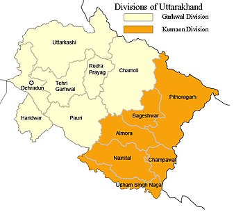
Districts in Garhwal and Kumaon. Garhwal lies to the north-west and Kumaon to the south-east
The following districts are under Garhwal since Ganga’s tributaries flow through all of them: Chamoli, Rudraprayag, Uttarkashi, Tehri Garhwal, Pauri Garhwal, Dehradun and Haridwar.
The rest of the districts that host the Sharayu river are in Kumaon: Pitoragarh, Bageshwar, Almora, Nainital, Champawat and Udham Singh Nagar.
For ease of administration, the government has formed two divisions too: GMVN and KMVN, which stand for Garhwal and Kumaon Mandal Vikas Nigam or organisations for divisional progress. There are also GMTU and KMTU for buses and taxis, which stand for Garhwal and Kumaon Motor Transport Union.
Why visit Garhwal
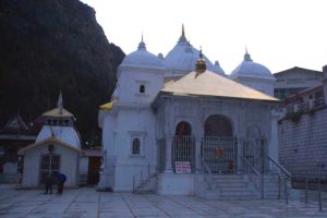
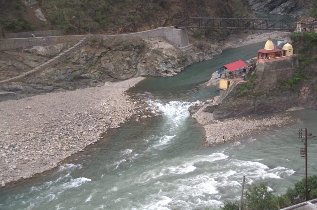
Religion, Ganga and Tirthyatra: While there are several reasons to visit Garhwal, the top reason for most Indians is religious. The Char Dham (4 holy abodes) trip that covers Yamnotri, Gangotri, Kedarnath and Badrinath is considered very holy by Hindus. In India 360, we also considered them as a study of geography of the Ganga river system. The four Dhams serve as the pilgrimage to the origins of Yamuna, Bhagirathi, Mandakini and Alaknanda rivers respectively. The four Dhams can also be supplemented by the Panch Prayag tour, where you get to see the five holy confluences of the tributaries of Ganga within the state. Dhauli Ganga joins Alaknanda at Vishnu Prayag near Joshimath. Nandakini joins Alaknanda at Nandprayag. Pindar joins Alaknanda at Karnprayag. The second-holiest confluence in the state is where Mandakini from Kedarnath joins Alaknanda from Badrinath at Rudraprayag. But the holiest confluence in Uttarakhand state is the confluence of Alaknanda and Bhagirathi at Devprayag. It is at Devprayag that the river gets the name Ganga.
-
- Yamnotri is near the origin of Yamuna river
-
- Gangotri is near the origin of Bhagirathi river
-
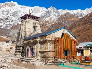
- Kedarnath is near the origin of Mandakini river.
-
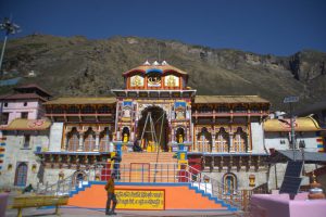
- Badrinath is near the origin of Alaknanda river.
Apart from the Dhams and Prayags, another series of important pilgrimage destinations are the 5 Shiv temples called Panch Kedar. Apart from Kedarnath which we have already covered above, the others are Tungnath, Rudranath, Madhmaheshwar and Kalpeshwar. Three more important Shiva temples, Gopeshwar, Koteshwar and Gupt Kashi Vishwanath too have their own ancient stories. Also of religious importance in winter are the villages of Janki Chatti, Harshil, Ukhimath and Joshimath. The idols of Yamnotri, Gangotri, Kedarnath and Badrinath respectively are brought to these villages when the original locations are snowed out. This is to keep the prayers and the consecration going. Other places of religious importance are Dhanolti and Srinagar (not to be confused with the capital of Jammu-Kashmir).
View of the Alaknanda-Mandakini confluence and the Rudranath temple at Rudraprayag.
While the above mentioned religious destinations are in the higher altitudes of the Shivalik mountains, there is one religious destination right at the level of the plains: Haridwar.
The name ‘Haridwar’ is actually a mispronunciation of the word ‘Hardwar’, with no ‘i’. The spelling with ‘Hari’ makes people misunderstand that the town must be significant to Lord Krishna. But Haridwar is very much a Shiva-centric town with the word ‘Har’ coming from ‘Har Har Mahadev’. ‘Har Dwar’ in Hindi / Sanskirt means the ‘the gateway to Lord Shiva’. This is because throughout Indian history, whether today or a millennium ago, this town has served as an excellent entry point to the Garhwal mountains, such that one can travel to any of the important mountain shrines dedicated to Lord Shiva. You will never hear a single town local say the name of the town with an ‘i’ in between.
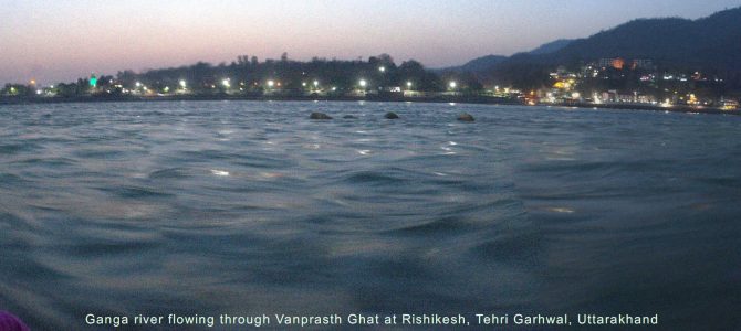
Haridwar is on the bank of the Ganga river after it has fully descended from the high peaks of the Garhwal mountains and after all its turbulent rapids have ceased in Rishikesh. The river is a picture of motherly calm when it flows through town.
Haridwar has several temples, both by the river side and on the two hills on either sides of the river. There are several river-side bathing spots designated as ‘Ghat’s. The most important Ghat in Haridwar is the one in the centre of town: Har ki Paudi, literally meaning the staircase of the Holy One.
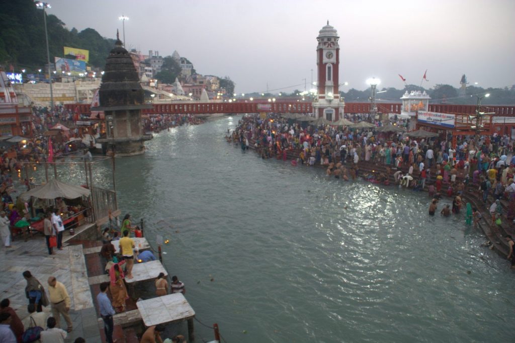
Haridwar’s heart, the Har ki Paudi Ghat, just after morning Aarti.
Adventure: Near Joshimath is the town of Auli, where beginner and advanced courses for skiing are offered. The courses commence in December and are available upto February, the period during which there is tightly packed snow. There are several trekking destinations in Garhwal region. Kedarkantha, Dayara top, Chandrashila peak, Rupin pass, Roopkund and several other treks are conducted by several trekking organisations, most notably YHAI and IndiaHikes. One of the most unique and beautiful treks in Garhwal is the valley of flowers, a valley which blooms with multi-coloured flowers on a lush green carpet of grass during the months of August to October.
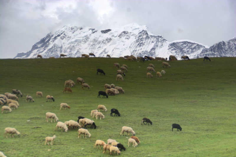
Sheep graze on Bedni Bugyal with Trishul peak as the backdrop. Bedni Bugyal is one of the most popular treks in Uttarakhand.
Wildlife: The Rajaji national park near Haridwar offers jeep safaris early in the morning. You will spot plenty of peacocks and bird life. If you are really lucky, you will spot a herd of elephants or even a tiger.
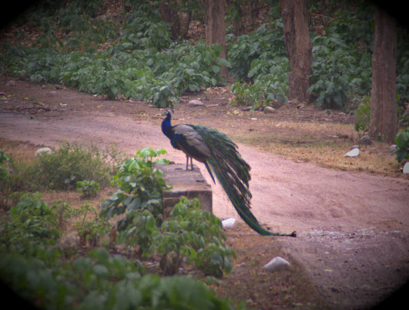
There are plenty of peacocks in Rajaji National Park.
Stylish British-built towns: There are two British-built towns in the state, one being the capital Dehradun and the other being the hill station Mussoorie. Dehradun is a cantonment with the Indian Military Academy. Dehradun is also the headquarters of the Indian Army’s Garhwal Rifles regiment. The town also has several hangout spots in the form of Sahastradhara falls, Malshi deer park and the Forest Research Institute. There are several malls, movies and pubs in the centre of town. You can get your jaws jammed by biting into a local sweet dish named ‘stick jaw’.
As the home of author Ruskin Bond, Mussoorie is a typical Himalayan hill station with breath-taking views of the Shivalik range, several walking paths among pine trees and viewpoints and beautiful wood buildings. Of note in Mussoorie are the Gandhi Chowk promenade, Sir George Everest’s estate, Mall road, Woodstock school, Tibba hill top sunset point and Kempty waterfall.
British-built Mussoorie is a hill station where you spend a lot of time taking strolls.
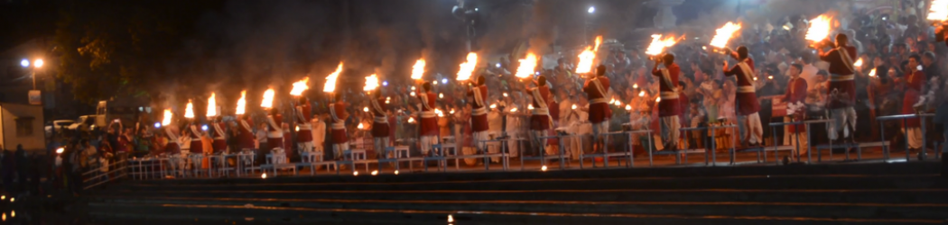
The most happening place in Garhwal: India 360 is in love with the most happening town in Garhwal region: Rishikesh. Situated right at the point where the Garhwal mountains end and the plains start, Rishikesh has it all. There are several temples for the religious like Neelkanth Mahadev and Kunjapuri. Then there is the must-watch spectacular Aarti performance at the Triveni Ghat. The Ram Jhula bridge area has several river-side beaches. The Laxman Jhula area as cafes, yoga classes and massage centres. And then there are two epic adventures. The first one is the extended (14, 17 and 21 km) white water rafting experience on the rapids of Ganga river as it descends furiously from the slopes of Garhwal mountains. Then there is bungee jumping from a height 83 metres (about 270 feet), which is sure to get your adrenaline pumped up for a long time. Finally there is a beautiful trek to the Neer waterfalls about 6 km from town.
-
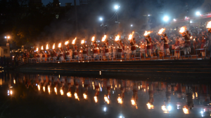
- Aarti to river Ganga in the evening at Triveni Ghat, Rishikesh
-
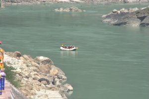
- River rafting at Rishikesh
-
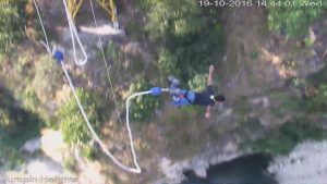
- Bungee jumping near Rishikesh
Why visit Kumaon
Kumaon is by far the more youthful and touristy side of Uttarakhand. This is due to the plethora of developed hill stations and India’s most famous tiger sanctuary.
Modern towns Almora, Nainital and Ranikhet: The trio of hill stations, all about 40 km from each other form a triangle in the south of Uttarakhand. All of them have several places of interest. While Almora town itself doesn’t have much to see, it is close to several view points, waterfalls and ancient Shiva temples. The Sharayu river valley flows deep below the ridge where the town is situated. Nainital is proud of its Naini lake, a lake around which the city has formed. ‘Nainital’ literally means ‘The eye lake’. This is because the lake is considered to be the eye of Sati. Hence the temple by the shore of the lake, Naina Devi, is one of the 64 Shaktipeeths. You can take up boating and yatching inside the lake. Ranikhet is a fascinating town with several forest trails and views towards some VIP mountains in the Himalayan range bordering Nepal. On a clear day, one can see Nandadevi and Trishul looming in the distance. The Kumaon regiment, headquartered at Ranikhet, has an in-depth museum about the Indian Army.
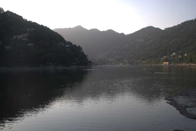
Naini lake at Nainital, believed to be the eye of Sati.
Gandhiji’s view of the Himalayas: At the town of Kausani, one can visit the Anasakti Ashram, a place where Gandhiji stayed during his travel around India. It is here that he wrote his book on Anasakti Yoga. Gandhiji was fascinated by the unhindered view of Chaukhamba, Nandadevi, Nandghunti and Trishul from the hill towering above Kausani town. You can enjoy the view too from the balcony specially built inside the complex of Anasakti Ashram.
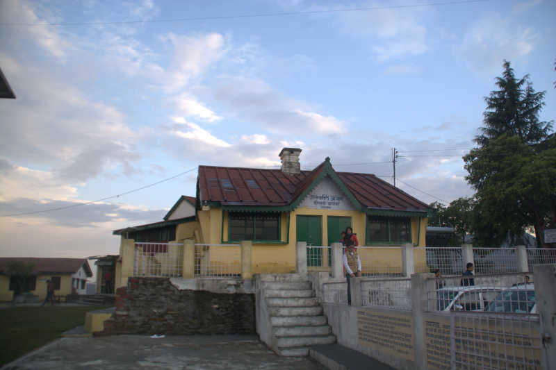
Anashakti Ashram at Kausani, where Gandhiji conceptualised Anasakti Yoga.
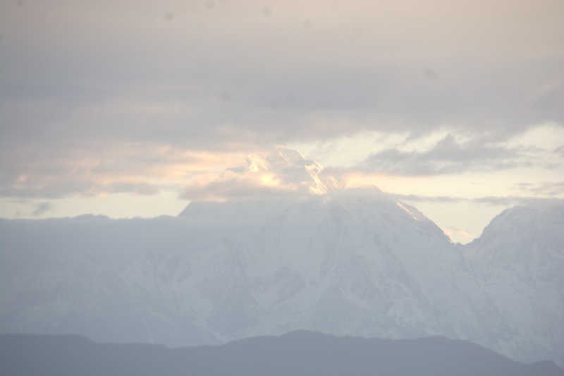
Snow peak (possibly Nandadevi) seen from Anasakti Ashram, Kausani.
Religion: Kumaon is not as abundant in religious places as Garhwal is, but there is no dearth of historically important temples / locations. I have already talked about Naina Devi temple as a Shaktipeeth. More fascinating is the complex of Shiva temples built by the Katyuri rulers near the town of Garud. This complex is called Baijnath, a local pronunciation of the name Vaidyanath. The complex is at the bank of Sharayu river. Also religiously important is the town of Bageshwar, with a Shiv temple Bagnath, worshipping the confluence of Gomti and Sharayu rivers. However, the most important religious activity in Kumaon can actually be classified as an adventure activity and it even straddles international borders.
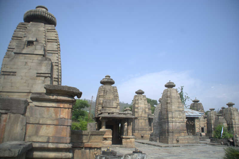
Baijnath temple complex
Adventure: Nandadevi Base Camp trek is the most sought after activity in the Kumaon region. That said, there are other challenging treks such as the base of Pindari glacier. If you want a combination of both religion and adventure, then try the 52-km walk circumventing the abode of Lord Shiva, i.e. Mt Kailash. This route will take you through three countries, viz. India, Nepal and China (Tibet). There are several permits required for this route and you should check the details from the authorities, since we haven’t tried this activity yet. Other adventures include paragliding near Almora and small activities like flying fox, mini rappelling and wall climbing at several hills around the important cities in the region.
Wildlife: A lion’s share (or should I say tiger’s) of Kumaon’s tourism is due to the wildlife at Jim Corbett National Park. Situated between the towns of Ramnagar, Nainital and Haldwani, this massive conservation forest is home to about 200 tigers. There are also several elephants and leopards. One can also spot barking deer, sambar deer, spotted deer and plenty of bird life. You should take a jeep safari instead of a canter safari. Previously, you could stay inside the forest at zones like Dhikala and Gairal. That used to give you a head start into the deep forest early in the morning. However that has been stopped and you need to exit and re-enter the forest for every safari. It takes 2 hours on rocky roads to go from the edge of the forest to the centre, so you should start really early.
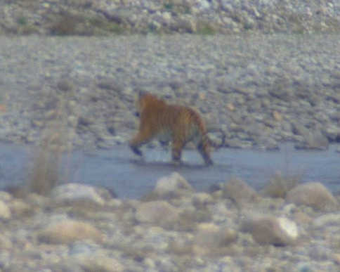
Tiger spotted in Dhikala zone of Jim Corbett National Park.
Conclusion
Uttarakhand is a state that feels like it is made of two states. While Garhwal region’s chief attractions are religion and Ganga, Kumaon’s plus points are modern hill stations, view points, adventure and wildlife. In India 360, we started with Rishikesh, covered the entire length of Ganga within Garhwal, then stepped into Kumaon via the Karnprayag – Gwaldam – Garud road and finally completed a full circle of the state by reaching Haridwar, before exiting the state. I hope this post helps you plan visiting the various parts of the state that the locals fondly call Dev Bhoomi (the land of the Lords). It’s your turn to enjoy.