We often hear people talk about travelling to Coorg or Kullu-Manali. These aren’t single towns, but entire districts enriched with beauty. Yes, there are complete districts in India filled with sightseeing treasures, unique experiences and delicious food. One such district is Satara district in Maharashtra. The district lies at the eastern foot of Sahyadri mountains and is blessed with two major rivers. Satara district is home to exotic fruits like strawberries. To see the unparalleled beauty of Satara district, one must visit it during the monsoon between July to September. Let’s go through Satara district in today’s post and see which places are the best to visit.
Geography of Satara district
The Sahyadri mountains have gifted Satara district with plenty of greenery and water catchment areas.
Satara is classified under Madhya Maharashtra region or central Maharashtra. It is in the Pune division of Maharashtra state. The Sahyadri mountains, which is the name given to the Western Ghat mountains within Maharashtra state, run parallel to the sea, about 100 kilometres inland. The region to the west of the Sahyadris, adjoining the sea is called Konkan. The region to the east is called Madhya Maharashtra. This region forms a plateau, called the Deccan plateau, which is elevated above the sea level at an average altitude of about 600 metres. The rain trapped by the Sahyadris flows vigorously in the form of several large rivers into the districts of Madhya Maharashtra. Two such rivers are Krishna and Koyna. The towns and villages settled on the banks of these two rivers collectively form the Satara district.
To the west of Satara district lie the Sahyadri mountains. Crossing the mountains towards the coastal side will lead us to Raigad and Ratnagiri districts, both famous for Alphonso mangoes. To the north of Satara district lies the industrially advanced Pune district. To the east is the Solapur district and to the south are Sangli and Kolhapur districts.
The district is blessed with 1000+ millimetres of rain every monsoon. Combined with the effect of 5000+ millimetres of rain in the adjoining Sahyadris, there are several waterfalls, lakes and dams in Satara district. This makes it a perfect destination for monsoon. The only destination not meant for monsoon is the Kaas plateau of flowers, the peak season for which are the months of October and November.
The important cities in Satara district are Satara city itself, Karad and Mahabaleshwar.
People of Satara district
Agriculture is the main occupation in Satara district. The monsoon makes the district perfect for sugarcane, paddy and several seasonal fruits and vegetables. Satara district’s prized fruit, strawberry, is grown on the slopes of Mahabaleshwar hill station.
Satara natives are known all over Maharashtra and in Karnataka for their toughness and physical strength. The biggest aspiration of Satara’s youth, both rural and urban, is to join the army or the police force. During the non-farming season, i.e., December – April, plenty of able-bodied persons from Satara district temporarily move to industrial Mumbai, Pune or Kolhapur to seek employment in factories, where they work as movers of heavy machinery or goods.
People are largely comfortable with government jobs. Private enterprise, especially Information Technology, is yet to enter Satara district. Most of the factories are based on agriculture, e.g. sugar mills, corn mills, paddy husking, etc.
Hinduism is the main religion in Satara district. Mahabaleshwar, a modern hill station today, has been a Kshetra for Lord Shiva for several centuries. In the vicinity of Mahabaleshwar temple are also two temples that worship Satara district’s major water bodies: a temple respected as the origin of Krishna river and another temple, Panchganga, that pays tribute to 5 rivers in the area. Muslims can be found in several pockets in Satara city, but not in the rural areas. Christianity can be seen in Mahabaleshwar and Panchgani, among the founders of boarding schools, which are mostly convents. Throughout Maharashtra, and also in Satara district, you will often see Buddhist colonies marked by gateways that are shaped like the arch in Madhya Pradesh’s Sanchi. These are people from lower castes who converted to Buddhism as resistance against the questionable practices by the higher castes. The conversion movement was led by Dr Babasaheb Ambedkar in 1956. These Buddhists are Navayana Buddhists.
It is not convenient to get by with only English and Hindi in Satara district, especially when you go deep into the country-side. People understand when you speak one of the two languages, but they struggle to reply and often revert to the local language, Marathi. Working knowledge of Marathi is highly recommended. If you do not speak the language, you should consider travelling with someone who does.
Here are the best places to visit in Satara district.
Satara city
Satara city is the hub for transportation to proceed to other destinations. Satara is the biggest city in the district and it is also the one with the maximum number of destinations close by. Kaas plateau, Vajrai waterfall, Sajjangad, Urmodi lake, Ajinkyatara, Chalkewadi windmill farm and Thoseghar waterfall are within 30 kilometres of the city centre. The district’s biggest railway station (Satara in the Pune division of the Central Railway) and bus terminal (on the national highway NH4: Mumbai – Pune – Kolhapur – Belgaum – Bengaluru – Chennai highway) are in Satara city as well. Both are extremely well-connected to the rest of India. There are no airports, the nearest one being at Pune. Satara city is a fascinating place to be, especially during the wee market hours in the evening, where you can get fresh fruits and the district’s own special sweet, Kandi pedha.
Karad
The Pritisangam at the north-western corner of Karad city overlooks the confluence of Krishna and Koyna rivers
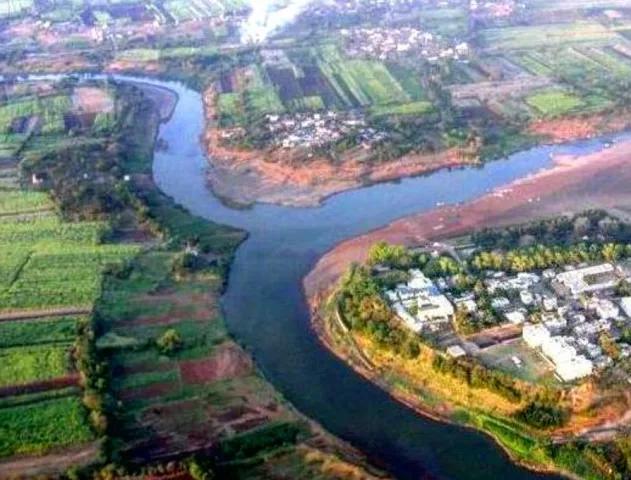
Industrially developed, Karad is the best-planned township in the district. It is situated near the confluence of the Koyna and Krishna rivers. The two rivers join forces to the north-west of the city. The Krishna-Koyna Pritisangam is an important destination for a Teerth Yatra (a pilgrimage that pays respect to major water bodies) in Maharashtra. Because of the two rivers, the region around Karad is extremely fertile.
Karad is a good interchange transport hub if you plan to travel to one of the two destinations: Koyna dam and Panhala fort. At Karad, one of the most beautiful Ghat highways in Maharashtra, i.e. Kumbharli Ghat, connects the city with Chiplun city of Ratnagiri district. This Ghat passes through Koyna Nagar. From this mountain road, there is a beautiful view of the Koyna river and several major waterfalls.
Mahabaleshwar – Panchgani
-
- View of Venna lake from table top, Panchgani.
-

- The famous strawberry cream delicacy at Mahabaleshwar. This region grows strawberries and even exports them.
Two hill stations were developed by the British in Satara district. Mahabaleshwar and Panchgani are 18 km apart. Both towns are famous for their strawberry farms. Mapro (Maharashtra Agricultural Produce) is a facility half-way between the two towns, that produces several delicacies such as chocolates, fruit squashes and candies with fruit flavours.
There are several viewpoints around the two towns, the most eye-catching one being the tabletop plateau at Panchgani. But there are others such as Savitri point that overlooks Savitri river and Arthur’s seat point that overlooks the flat plains of Konkan.
The British established several boarding schools in both the towns. Students from all over Maharashtra and even several parts of India relocate to the two towns during their schooling years. Most of these schools are run by Christian missionaries today.
There is a complex of five ancient temples in Old Mahabaleshwar. One of those 5 temples is worshipped as the source of Krishna river, south India’s longest river, that flows through Maharashtra, Karnataka, Telangana and Andhra Pradesh.
The Lingmala waterfall near the village of Metgutad, 9 kilometres from Mahabaleshwar, is one of the several major waterfalls in the district. There is so much to see in these two towns put together that we promise you a seperate article.
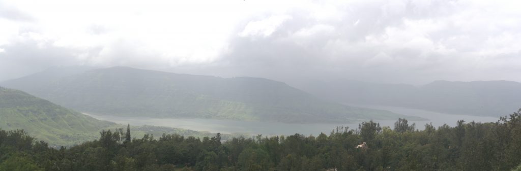
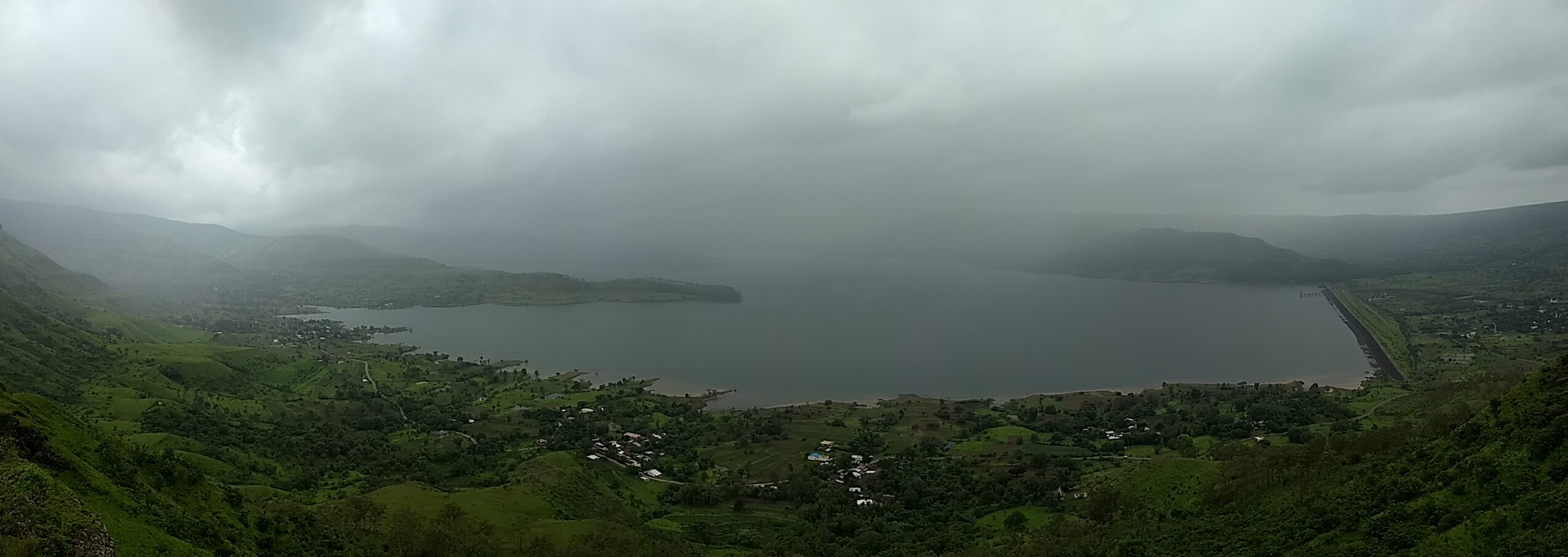
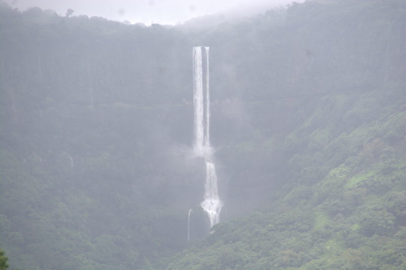
Kaas plateau, Vajrai waterfall and Tapola Lake
-
- Vajrai waterfall as seen from Kaas plateau
-
- A view of the Tapola lake, created by the Koyana river backwaters, from the Tapola Ghat near Mahabaleshwar.
Two highways lead from Satara city to Mahabaleshwar. The wider and more frequently used route goes through the town of Medha. This highway is featureless, save for a few good views of the forests in the Ghats. Let’s talk about the must-visit sites on the not-so often used route between Satara and Mahabaleshwar. This road is called the Bamnoli Ghat and passes through some of the best features Satara district has to offer.
20 kilometres from Satara city on the Bamnoli Ghat is a unique work of nature. Every year, just after the monsoon and during the onset of what can be called the peninsular Indian autumn, the ground of the entire plateau is covered in flowers of various colours. The blooming starts at the end of September and continues to the middle of November. Thereafter the ground dries and the flowers wither away by new year’s day. A rule of thumb to visit this place is between Navratri festival and new year.
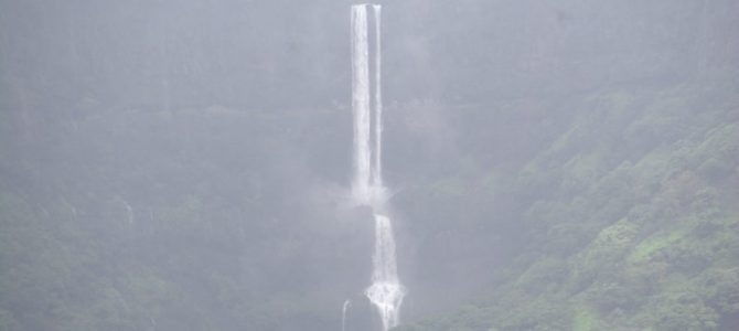
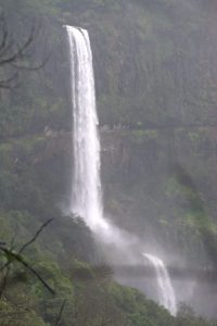
2 kilometres downhill from the Kaas plateau is the Kaas lake. The lake has an expansive meadow of grass on the banks. One can bring a tent and camp here for the night. 4 kilometres further to the west is the village of Bamnoli, where Urmodi river forms a deep gorge surrounded by hills on three sides. From one of the sides, the river falls in a 560-metre waterfall forming three cascades. This waterfall is named the Vajrai waterfall. It is a perennial waterfall, but the best flow is during monsoon. Vajrai is one of the most spectacular waterfalls in all of India.
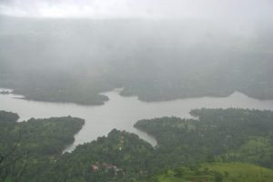
As the road progresses towards Mahabaleshwar, it descends to a river basin, where the backwaters of the Koyna dam makes a uniquely shaped lake. This lake is in the village of Tapola. When seen from a higher altitude, the lake looks like a 5-pointed star. At the lake itself, one can see the surrounding Sahyadris and its waterfalls. Motorboats are available at the banks of the lake at Tapola village, which is being developed as a resort.
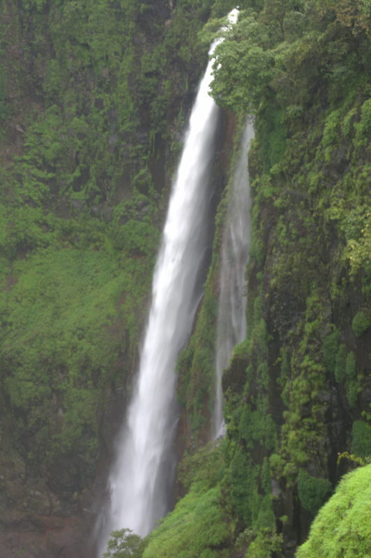
Sajjangad, Urmodi and Alewadi
View of Urmodi lake from the viewpoint at Sajjangad
Vajrai waterfall from Alewadi village.
During the 17th century, Chhatrapati Shivaji conquered the Sajjangad fort, which lies at the top of a hill 16 kilometres from Satara city, from the hands of the Muslim Bahamani rulers. To restore Sajjangad and Satara as a centre of Hinduism, Shivaji established an Ashram for Sadguru Swami Samarth Ramdas inside the fort premises. It continues to be an Ashram today. The Samadhi or the resting place of the Swami is enshrined inside the fort complex. Around the complex are several temples and a Yatri Niwas or a devotee’s lodge, where one can stay free of cost and make a donation if he/she so desires. There is no obligation to pay for the stay or the food. Lunch and dinner are served as prasad in a community hall.
The best feature of Sajjangad is the view of the expansive Urmodi lake from a viewpoint. The azure water of the lake looks beautiful in contrast to the greenery around. The Urmodi dam supplies potable water to Satara city. One can drive right near the bank of the Urmodi lake on a road that leads from Satara to Alewadi. The road that starts at Satara abruptly ends at Alewadi. The village is surrounded by thick forests on all the sides. But what is special here? At Bamnoli, one can see the Vajrai waterfall plunging into the depths of the gorge deep down. But from Alewadi, one can see the waterfall pouring from a high above!
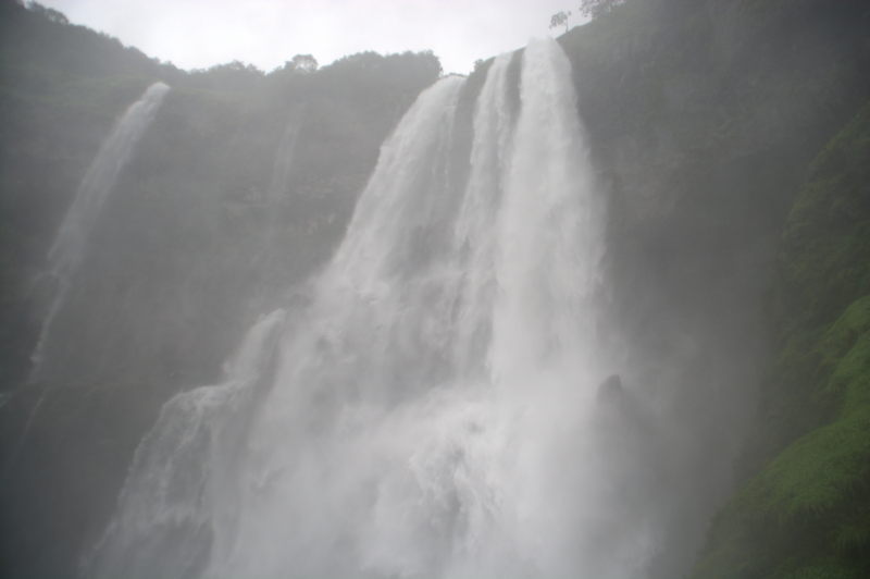
Thoseghar and Chalkewadi
Thoseghar waterfalls.
As if the jaw-dropping beauty of Vajrai waterfall were not enough, the Thoseghar waterfall series gives you more jaw-dropping and wide-eyed moments. 25 kilometres from Satara on the same road that also has Sajjangad, a small park with a guided walkway takes you through a forest trail and suddenly opens up to a void formed by the Koyna river surrounding by vertical cliffs on three sides. On each cliff is a waterfall. This series of waterfalls is called the Motha Dhabdhaba (the big waterfall), the height of which is 380 metres. Further upstream is another waterfall of 180 metres, which is called the Lahaan Dhabdhaba (the small waterfall).
The Thoseghar falls viewpoint seems to be as dangerous as it is beautiful. People seem to have done a lot of foolish things in a drunken stupor or plain negligence, ultimately perishing in a 380-metre fall. To one side of the viewpoint is a large board written in Marathi, that lists the names, native cities, ages and the dates of death of several individuals who fell to their deaths. The ages range from 11 to 60. If you understand Marathi, one look at the board is enough to prompt you to be more careful when taking selfies! The board had 13 names, the most recent death having happened in the same monsoon season (2017) that we visited!
On the same hilltop where the Thoseghar waterfall series drop off the cliff, a field of windmills can be seen. This field is in Chalkewadi village. It was started by the government of Maharashtra to harness the strong winds in the district and use it to generate power. The field also has a grass meadow with colourful flowers, similar to the ones at Kaas.
Kumbharli Ghat and Koyana Nagar
Ozarde waterfall on the way from Koyna to Kumbharli.
A view of Koyna dam from Koyna Nagar town.
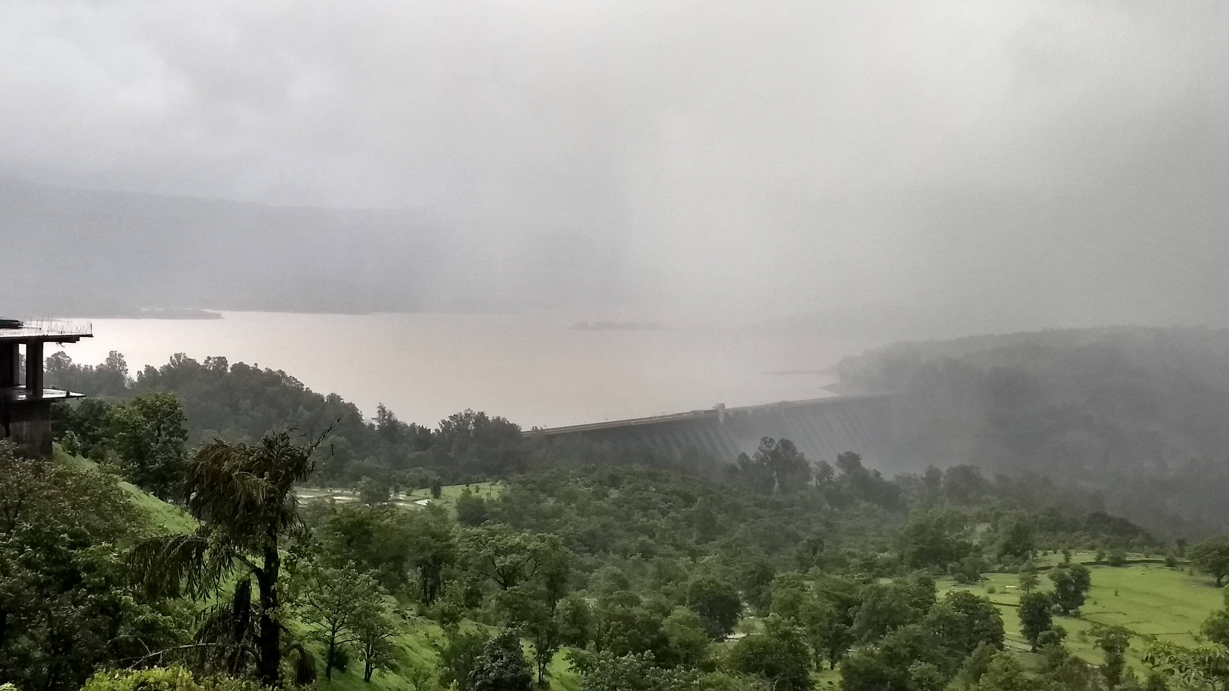
Kumbharli Ghat is a mountain pass highway that connects Karad in Satara district to Chiplun in Ratnagiri district. The summit of the Ghat is at the village of Kumbharli, which is a village overlooking the Koyna dam. However, the highlight of the route is the town of Koyna Nagar and the things to see within 6 kilometres of the town. A kilometre from town is the complex of Koyna dam, the dam built over Koyna river. This dam is mainly used for hydel power generation at the station at the base of the dam. The lake formed by the dam is named Shivaji Sagar. The lake is fed by the several waterfalls that rush down from the hills around Kumbharli village.
Let’s look at the waterfalls. There are three huge waterfalls near Koyna Nagar. Two of them are right on the Kumbharli Ghat highway. You can simply park your vehicle and walk right in front of the cascade. The third one, Ozarde, is the biggest and the thickest. The region around the waterfall has been converted into a park with a stair walkway leading you midway to a hill that overlooks the mammoth waterfall from just a few metres away. The view is spellbinding. You stand in front of a giant which pounds down on the rocks in front of you with a roar. You are sprayed with mist and it is very difficult to hold a camera lens without fogging it completely.
Pratapgad fort
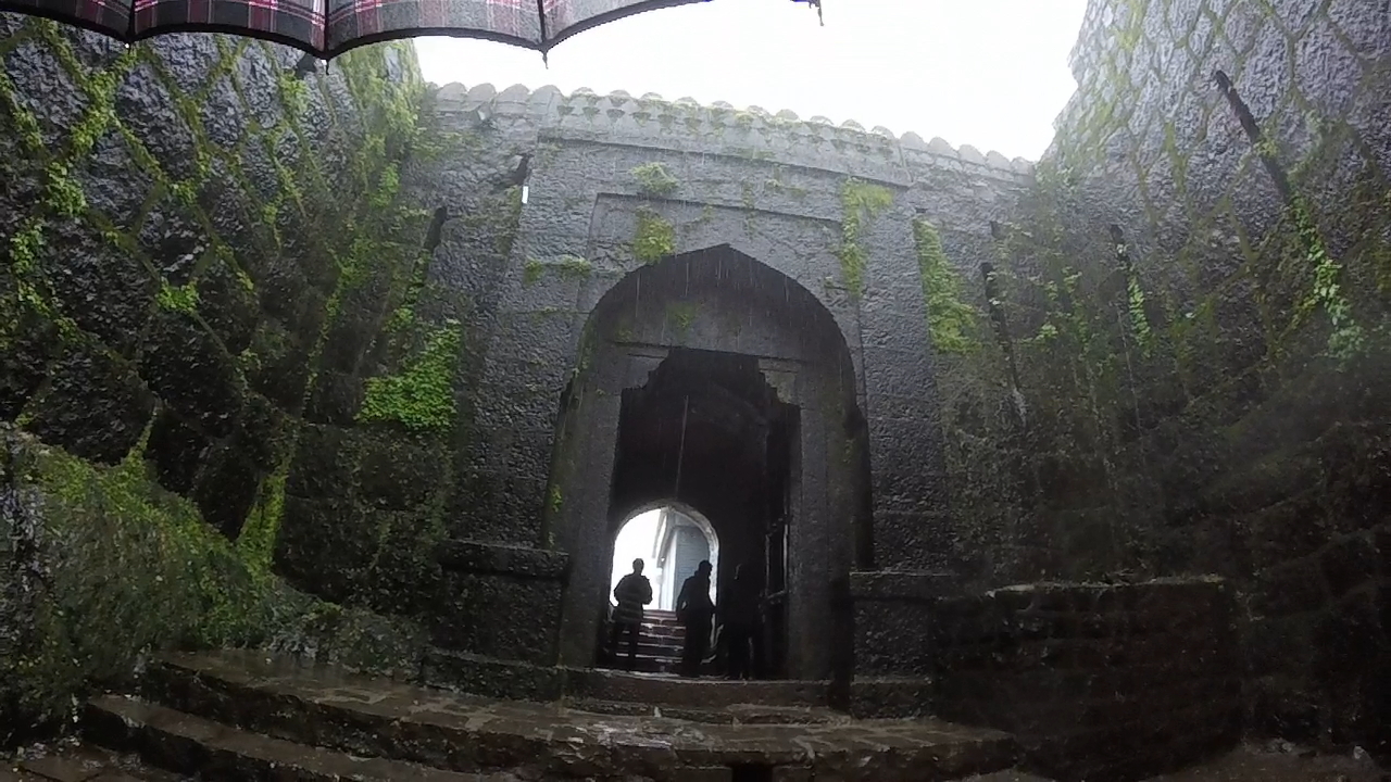
The main entrance to Pratapgad fort.
Pratapgad is a Maratha-era fort located on the Ambenali Ghat, the highway that goes to Mahabaleshwar from Mumbai via Poladpur. There is a piece of history about how Chhatrapati Shivaji killed a Mughal emissary named Afzal Khan in the premises of this fort. History aside, the view from the walls of the fort is amazing. In the monsoon, the view is covered by thick clouds. Inside the entrance of the fort, a flight of stairs takes you to the citadel of the fort, where there is a Bhavani Mata temple and a bronze statue of Shivaji atop a horse.
A short video of Satara district
We made a short video of Satara district on our YouTube channel. You can watch it here.
What to eat
In Satara district, you get typical Maharashtrian food everywhere, be it in the middle of Satara city or the Ghats. Soft chapati with a gravy made of pulses such as moong, masoor or matki is the go-to lunch and dinner. This can be supplemented with daal and rice.
Snack items include misal pav, usal pav, vada pav and bhaji.
Breakfast items are very limited since the district is laidback. It is common to see restaurants open only after 9:30 am, even 10:00 am. Not ideal if you have a long day’s itinerary planned. People eat one of the snack items (already mentioned) as breakfast. There are some breakfast joints in Satara city where you can find poha. Many restaurants list upma as an item on their menus but don’t have it for real. For a decent breakfast, Karad city offers many good options including a south Indian joint beside the city’s main flyover. If you stay at a decent resort in Mahabaleshwar or Panchgani, then you’ll most likely get good parathas.
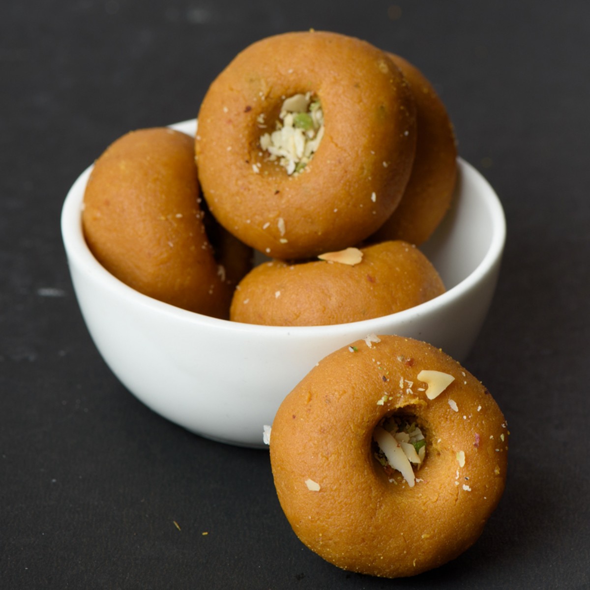
Kandi Pedha is unique to Satara district
Something unique to Satara district is Kandi Pedha. This is a milk sweet made of khoa or milk thickened by boiling away all the water inside the milk. The khoa gives the sweet its basic shape. But the taste comes from sugar, ghee, cardamom (elaichi) and saffron (Kesar). Kandi pedha differs slightly from regular pedha. In regular pedha, the khoa is white, but in Kandi pedha, the khoa is burnt until it shows a deep brown colour. You can get Kandi Pedha from all over Satara city, but the best ones are in the sweet shops surrounding the bus terminal.
Another local sweet dish is the mango barfi or aamba barfi as it is called in Marathi. This is a barfi made from mango pulp, sugar and all-purpose flour. Mangoes are easily available in Satara district from across the Sahyadri mountain range in Raigad and Ratnagiri districts.
Conclusion
Our list of attractions in Satara district is not exhaustive. But we have attempted a list of the best spots. In future posts, we will dive into each of the locations in detail. If you are planning a trip to Maharashtra in monsoon, then look no further than the enchanting beauty of Satara district.
Scintillating and mouth watering.